Slower week ahead of a very large S/SW groundswell Sunday
Nias, Mentawai, South Sumatra forecast by Craig Brokensha (issued Tue 19th Aug)
Best Days: Wednesday, Thursday morning, Friday afternoon, Saturday, Sunday and Monday for experienced surfers
This week (Aug 20 - 22)
There's been fun waves across exposed coasts the last few days with the arrival of a couple of long-range and inconsistent S/SW groundswells.
The strongest filled in today with infrequent 4-6ft sets due across exposed spots in the Ments.
Over the coming days, today's S/SW groundswell will slowly drop, bottoming out Thursday evening under fresh and gusty SE trades in South Sumatra and weaker SE winds around the Ments and Nias.
A slight kick in long-range S/SW groundswell is due later Friday from distant polar frontal activity south-west of WA, but to no major size above 5ft in the Ments on the sets, but South Sumatra should see the odd 6ft bomb near dark.
This weekend onwards (Aug 23 onwards)
 Of much greater importance and touched on last update is the forecast from this weekend onwards, as we're expected to see two very large and powerful S/SW groundswells impacting Indonesia.
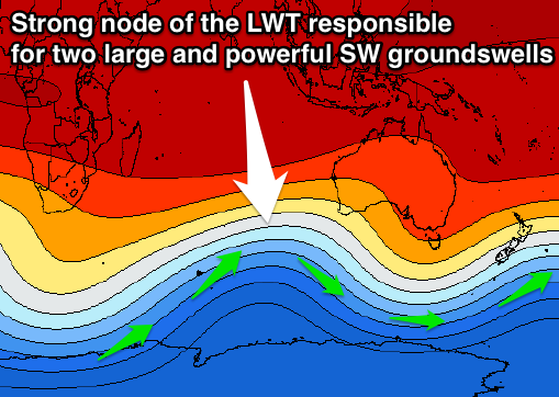
This will be related to a strengthening node of the Long Wave Trough stalling south-west of WA tomorrow, and remaining in the area for almost a week.
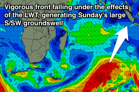
This is currently steering and strengthening a vigorous polar front pushing up from the south-east of South Africa, north of Heard Island and directly towards Bali, protruding very north into the Indian Ocean.
A broad fetch of severe-gale SW winds will be generated in our swell window, and the extra projection up towards the Equator will help generate a large, powerful and fairly consistent S/SW groundswell.
 The swell is due to arrive during Saturday afternoon, building to at least 8ft by dark in the Ments, and a larger 10ft+ in South Sumatra. A peak is due during Sunday morning to 10ft to possibly 12ft at exposed spots in the Ments with oversized 12ft to possibly 15ft surf at exposed spots in South Sumatra.
Winds look as if they'll be variable around the Ments with fresh E/SE trades in South Sumatra but we'll review this again Thursday.
A secondary large but not as big S/SW groundswell is due next Thursday as another vigorous polar front falls under the steering and amplifying effects of the Long Wave Trough.
This secondary front will be a touch stronger, but shorter-lived resulting in a slightly smaller and less powerful swell compared to Sunday's.
Still the Ments should see 8ft to occasionally 10ft surf through the peak Thursday morning, with larger 10-12ft sets in South Sumatra. Winds may increase a touch from the NW Thursday afternoon around the Ments, while South Sumatra should see weaker SE trades. More on this on Thursday though.
16 day Mentawai forecast graph
16 day Nias forecast graph
16 day South Sumatra forecast graph


Comments
Bring it on!!! with my eldest almost 6 and the younger twins almost 4, I'm back in the business of travelling with the boys to Indo for some proper juice, first extended trip to the wilderness in 8 years (without 3 kids and a mountain of gear in tow...) So excited to be on a plane this time next week with two of my oldest, frothiest mates!!!!