Ments: S'ly swells all week, large SW groundswell Monday
Nias, Mentawai, South Sumatra forecast by Craig Brokensha (issued Tue 29th Jul)
Best Days: Every day over the coming period (smallest Saturday evening)
This week and weekend (Jul 30 – Aug 2)
Our recent run of S/SW groundswell in the 6ft+ range is expected to continue through the coming few days with the frontal activity firing up late in our swell window up towards WA over the weekend producing good pulses of S/SW groundswell.
The strongest is expected tomorrow afternoon with 8ft sets due at exposed south facing breaks in the Ments, with the odd bigger bomb possible around South Sumatra when the swell peaks earlier through the morning. Nias will be smaller.
A slow drop in size is then due through Thursday and Friday, bottoming out overnight Saturday.
Into Sunday a dead S'th (even a touch S/SE) groundswell is due across the region, but it will only really hit South Sumatra with any real size, as it'll be generated directly south-west of WA. Size wise we should see 6ft sets across South Sumatra, with smaller 5ft bombs around the Ments at exposed south facing breaks.
Winds are looking good with generally variable breezes across all locations ahead of fresh to strong SE trades in South Sumatra over the weekend.
Next Monday onwards (Aug 3 onwards)
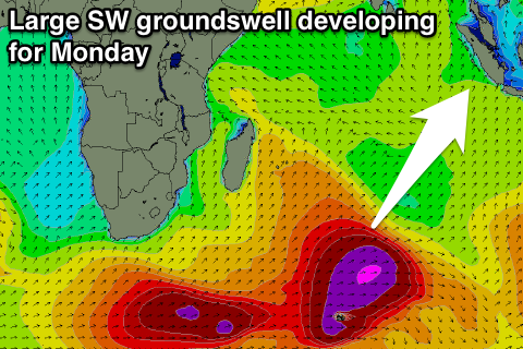
As touched on over the past week, the longer term outlook is exciting with a large and powerful SW groundswell lining up for the first week of August. This will be produced through the Southern Indian Ocean by a very broad and strong couple of cold fronts. An initial fetch of severe-gale SW winds south-east of South Africa today will set up an active sea state for a much broader and stronger frontal system to generate an additional fetch of severe-gale W/SW winds over.
 This will generate a large and powerful SW groundswell, arriving overnight Sunday, building strongly through the day Monday to a late peak around 8-10ft in the Ments. Nias will be a touch smaller, while South Sumatra can expect larger bombs to 12ft at exposed breaks. Winds may become an issue with moderate NW breezes a possibility around the Mentawai and Nias regions, but we'll look over this again on Thursday.
16 day Mentawai forecast graph
16 day Nias forecast graph
16 day South Sumatra forecast graph

