Ments: Slower period ahead with some better swell later next week
Nias, Mentawai, South Sumatra forecast by Craig Brokensha (issued Tue 10th Jun)
Best Days: Every day at exposed breaks
This week and weekend (Jun 10 - 15)
A great run of waves from Friday afternoon through the weekend should be continuing into this morning, but make the most of the size as we'll be heading into a period of smaller, but still moderate sized surf through the coming period.
The reason for this is a large blocking pattern across our prime swell window in the Western Indian Ocean. A large blocking high has been sitting to our south-west for a while now, with frontal systems focussing more up towards WA and Bali, with smaller side-band S'ly groundswell energy expected to push up towards us.
This will keep exposed spots topped up with inconsistent 3-5ft waves through the end of the week, but after this we'll see the swell bottoming out through the weekend and early next week to a smaller and very inconsistent 3ft or so. There should also be some funky S/SE swell in the water over the weekend and early next week (Mentawais only) from a strong south-east ridge sitting to our south and this may come in at a slightly bigger 3-4ft+ at exposed south-east facing breaks.
Winds through the end of the week and weekend look to be light from the NW and mostly variable at times, favouring those exposed breaks.
Next Monday onwards (Jun 16 onwards)
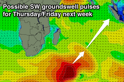
 Besides a couple of inconsistent background SW groundswells through Tuesday and Wednesday we won't see anything significant until later in the week next week.
This will be related to some better polar frontal activity pushes from below South Africa and towards Heard Island.
At this stage we should see a couple of pulses in the 6ft+ range Thursday and Friday around the Ments, but we'll review this again Thursday.
16 day Mentawai forecast graph
16 day Nias forecast graph
16 day South Sumatra forecast graph

