Indonesia/Maldives forecast Dec 10
Indian Ocean Basin analysis by Craig Brokensha (issued Tuesday 10th December)
This week through next (Dec 11 - 20)
Following good surf over the weekend and into yesterday, our attention looks towards the large, long-period SW groundswell due across the region tomorrow and Thursday.
As touched on in last Thursday’s comments, satellite observations of the swell generating low were great with 50-60kt core winds registered around its core.
In saying this, the swell came in a little under expectations across Western Australia yesterday afternoon/evening and this morning so I’d be a little cautious on the upper size band forecast below.
Still, it will be a strong swell with lots of power and push and large on the true magnets, building through tomorrow and peaking late/overnight before easing into Thursday and the end of the week.
The surf will continue to ease ahead of a small, long-range mid-period SW swell next Monday, but this will only keep the magnets topped up with the odd wave.
Some better, moderate to large sized mid-period SW tending S/SW swell is due mid-late week, generated by a healthy frontal progression firing up through the southern Indian Ocean over the coming days.

Various fetches of W/SW gales along with embedded severe-gales should produce a good sized swell that’s due to arrive later Tuesday but peak through Wednesday/Thursday to 6ft to occasionally 8ft across the magnets, easing into Friday. We’ll have a closer look at this on Thursday.
Local winds have been strong out of the western quadrant thanks to an active monsoon but we’ll see them slowly easing over the coming days and tending more W/NW-NW ahead of weaker afternoon sea breezes, more NW into the weekend. Into next week winds look more W/NW to W/SW.
Over in the Mentawais, strong NW winds are persisting across southern regions, weaker and more W to the north, with NW winds due across all locations into the end of the week, stronger in the south.
Winds will ease off but shift more W-W/SW into the weekend before reverting back to the NW through next week. This is a classic negative Indian Ocean Dipole mode setup, emanating from the warm waters off north-west Western Australia, combined with an active monsoon signal.
----------------------------------------------

Maldives: The SE trade-swell has peaked across the region and will ease off slowly over the coming week, but we’ve got out strong S’ly groundswell in the water today, with that also due to ease tomorrow.
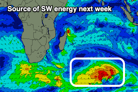
The next healthy frontal progression should generate persistent pulses of fun sized S’ly swell, initially small Friday and then stronger Sunday but more so Monday next week, generated by a strong low currently south of South Africa.
Moderate + sized pulses of size are due and moderate W/NW-NW winds this week look to dip W/SW on the weekend and NW early next week before starting to strengthen.
Eastern Indonesia:
Large SW groundswell building slowly tomorrow, reaching 6-8ft late in the day across the magnets on the sets, easing slowly from 6-8ft Thursday, smaller into the weekend.
Small, mid-period SW swell for Monday to 3-4ft across exposed breaks.
Mod-large SW groundswell next Wednesday to 6ft to possibly 8ft across exposed breaks, easing slowly Thursday from a similar size.
Strong W/NW-W/SW winds, easing over the coming days and tending more W/NW-NW in the mornings ahead of sea breezes.
Winds tending moderate W/NW-W/SW through next week.
Uluwatu 16-day Forecast Graph/WAMs
Western Indonesia/Mentawais/South Sumatra:
Large sized SW groundswell tomorrow to 6-8ft across exposed breaks, easing from Thursday into the weekend.
Small-moderate sized, mid-period SW swell building Sunday, reaching 4ft across exposed breaks, easing Monday.
Mod-large SW groundswell building Tuesday, peaking next Wednesday to 6ft to possibly 8ft across exposed breaks, easing slowly Thursday.
Strong NW winds across southern regions, weaker and more W to the north, with NW winds due across all locations into the end of the week, stronger in the south.
Winds will ease off but shift more W-W/SW into the weekend before reverting back to the NW through next week.
Mentawai 16-day Forecast Graph/WAMs
Maldives:
Slowly easing SE trade-swell this period.
Moderate sized, inconsistent S’ly groundswell today to 4ft across the southern atolls.
Small, inconsistent S’ly groundswell Friday, with some better energy Sunday but more so Monday to 4ft+ across the southern atolls (smaller Male).
Reinforcing S’ly swells for the rest of the week.
Moderate W/NW-NW winds over the coming days, shifting W/SW on the weekend and then back to the NW early next week, stronger as the week progresses.


Comments
Latest notes are live.
Thanks Craig , wet season is well and truly here , raining everyday , heavy downpours and strong onshore winds on NL . Nothing like last year with clear blue skies and ESE winds . Letting a cut foot heal up before heading to east coast Bali again around 18th 19th . Look forward to your updates .