Indonesia/Maldives forecast Dec 5
Indian Ocean Basin analysis by Craig Brokensha (issued Thursday 3rd December)
This week through next (Dec 6 - 13)
A large pulse of S/SW swell should have kicked in yesterday afternoon, with it easing from early today, further down over the coming days.
The easing trend will be drawn out thanks to healthy, weaker frontal activity behind the main swell generating low, while a slightly better aligned fetch of SW winds to the south-west of Western Australia yesterday should produce a fun mid-period pulse for Sunday afternoon and Monday morning.
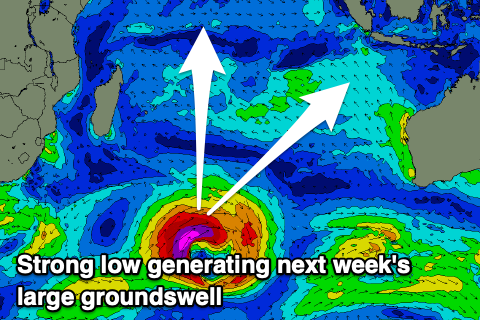
We then look at the large SW groundswell due into Wednesday/Thursday. The models aren’t picking up this swell too well at all, but the source looks great, that being a strong low that’s formed south-east of Madagascar. A fetch of severe-gale to storm-force W/SW winds will slowly move ease through our south-west swell window, with the low breaking down to the South West of Western Australia on Saturday.

The fore-runners are due to be in the water Tuesday evening while the swell proper should build gradually through Wednesday, peaking later to 8ft across exposed breaks, with easing sets from 6-8ft on Thursday.
Local winds will start to freshen from the west on Sunday but really strengthen into next week as we see the first monsoonal push of the season. Strong W/NW-W/SW winds are initially due, shifting W/NW from Wednesday and then easing slowly later week.
Over in the Mentawais, winds look to deteriorate across all locations over the coming days with strengthening W/SW-W winds tomorrow, tending more SW to the north, then stronger W/NW-NW on the weekend and next week, W/SW-SW to the north Saturday then W/NW-NW Sunday and NW next week.
Besides the strong SW groundswell mid-next week, ahead of this from the weekend, moderate sized levels of mid-period S’ly swell are due from a fetch of strong S/SE-S winds south of the region.
----------------------------------------------
Maldives: The swell is reaching a low point across the region and besides a small lift in mid-period S/SE energy tomorrow and Saturday, the better run of surf is due to kick in from Sunday but more so next week.
That will be small to moderate levels of SE trade-swell energy, generated by a great fetch of SE winds feeding into the deepening monsoon signal across Indonesia.
Winds look to reach a peak through the weekend, resulting in a peak in size early-mid next week, easing thereafter.
Some stronger S’ly groundswell from the low forming south-east of Madagascar is due to be in the water Tuesday with moderate sized sets, easing Wednesday.
Following this the outlook remains slow ahead of a possible resurgence in SE trade-swell the following week.
Eastern Indonesia:
Large, easing S/SW swell from early this morning, smaller over the coming days.
Small-mod sized, mid-period S/SW swell for later Sunday and Monday morning to 4-5ft across exposed breaks.
Large SW groundswell building slowly Wednesday, reaching 8ft late in the day across the magnets on the sets, easing slowly from 6-8ft Thursday.
Variable winds tomorrow and Saturday with afternoon sea breezes, with freshening W/SW winds from Sunday, stronger W/NW-W/SW early next week then W/NW from Wednesday. Winds easing late week.
Uluwatu 16-day Forecast Graph/WAMs
Western Indonesia/Mentawais/South Sumatra:
Easing S’ly swell over the coming days after peaking today.
Moderate sized mid-period S’ly swell for Sunday/Monday to 3-5ft across exposed breaks.
Large sized SW groundswell building Tuesday afternoon, reaching 6ft+ later, with a peak Wednesday morning to 8ft across exposed breaks, easing Thursday.
Strengthening W/SW-W winds tomorrow, tending more SW to the north, then stronger W/NW-NW on the weekend and next week. W/SW-SW winds to the north Saturday then W/NW-NW Sunday and NW next week.
Mentawai 16-day Forecast Graph/WAMs
Maldives:
Small S/SE trade-swell tomorrow and Saturday to 3ft across the southern atolls (smaller Male).
Small to moderate sized SE trade-swell building slowly Sunday, peaking early next week to 3-4ft across exposed breaks, easing from mid-week.
Moderate sized, inconsistent S’ly groundswell for next Tuesday to 4ft across the southern atolls.
Moderate W/NW-NW winds across southern regions for the coming days, lighter to the north.
Weak W/NW winds across the southern regions next week, weak E/NE to the north with more variable winds later week.


Comments
Latest notes are live.
Thank you Craig , pumping today, talking to a guy in the water this morning who said his mate went out at nusa dua thinking it was 3-4 ft . Then sitting out there , was thinking where’s the fucking sets . Next minute a mountain out of nowhere was unloading on his head . Came in with tail between his legs and didn’t catch a wave . I was thinking after this swell it was going tiny so thanks for this update , will have to change plans.
Haha oh dear. Thanks for the update! Be interesting to see how next week's swell comes in.
Nusa Dua, 2-3 ft with 6 foot sneaker sets.
Nusa Dua 6-8 ft, then expect 12 ft clean ups.
If it looks 3-4 ft from beach, ya know its solid and you will always cop some on the head.
A couple of great satellite passes of the low. This swell will have grunt!
I was talking to a mate that works on an FPSO in the far western Timor Sea. They have been told to brace for 60-80kt winds forecast for next week.....
Mental, would need a cyclone to form though that's not out of the question.
Sorry, edit, not next week, week after, 18th December.
Swellnet graphs showing sizey swell hitting then.
What's the level of confidence on that one this far out Craig?
Or should I be patient and wait for the next forecast notes
Yeah check back tomorrow :)