Indonesia/Maldives forecast Aug 29

Indian Ocean Basin analysis by Craig Brokensha (issued Thursday 29th August)
This week through next (Aug 30 - Sep 6)
The swell has been easing across the region since Tuesday, with some new, inconsistent SW groundswell due into tomorrow afternoon and Saturday morning, though only moderate in size.
We’ve then got out moderate + sized pulse of mid-period S/SW swell due into later Sunday and Monday morning, with the models over-forecasting the size and incorrectly combining swells.
The source wasn’t overly impressive but it should bring a more consistent and slightly bigger increase in size compared to the energy due over the coming two days.
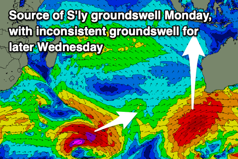
There’s also due to be some inconsistent S’ly groundswell in the mix Monday across select locations, generated by a strong frontal progression currently south-southwest of Western Australia.
We then look to the strong polar low that’s formed west of the Heard Island region, with this generating a fetch of storm-force W/NW winds on the periphery of our southern swell window.
The low will weaken tomorrow while racing off under Australia, limiting the size potential from this system.
We’re now looking at a moderate-large, inconsistent S/SW groundswell that should arrive Wednesday, building to a peak later in the day/overnight and then ease on Thursday.
The models are again incorrectly combining swells so expect less than what the charts are showing.
Following this, weaker storms look to generate smaller, moderate to possibly large pulses of reinforcing swell for later in the week, but more on this Tuesday.
----------------------------------------------
Over in the Maldives, we’ve got easing levels of mid-period S’ly swell and S/SE trade-swell, with the S’ly energy picking back up a little through tomorrow.

Better levels of S/SE tending SE trade-swell will develop over the weekend and into next week though as a great fetch of E/SE winds developing south-southeast of the region starts migrating east tomorrow.
Unfortunately the fetch will weaken on the weekend resulting in the largest pulse of S/SE energy filling in Sunday/Monday, easing while tending more SE in direction Tuesday, Wednesday and Thursday.
We’ll hopefully see the trades pick back up mid-late next week in our south-eastern swell window, generating some moderate sized SE trade-swell for Friday/Saturday next week, easing thereafter.
S’ly swell wise, a relatively weak frontal system passing the south-east of South Africa looks to generate some small to moderate sized energy for the southern atolls later next week, with nothing further to really follow.
Eastern Indonesia:
Small-moderate sized, inconsistent SW groundswell for tomorrow, building to 4-5ft, easing from 3-5ft Saturday morning
Moderate sized, mid-period S/SW swell for later Sunday, peaking Monday morning to 5-6ft across exposed breaks with some infrequent S’ly groundswell to a similar size in the mix.
Mod-large S/SW groundswell building Wednesday, reaching 6ft to possibly 8ft across exposed breaks later, easing Thursday from a slightly smaller size.
Smaller, reinforcing S/SW groundswell late week to 6ft.
Moderate S/SE winds tomorrow and over the weekend, variable each morning, with moderate to fresh E/SE-SE trades for next week.
Uluwatu 16-day Forecast Graph/WAMs
Western Indonesia/Mentawais/South Sumatra:
Inconsistent, moderate + sized SW groundswell today to 5-6ft across exposed breaks, easing tomorrow.
Moderate sized S’ly swell for Sunday afternoon to 5-6ft across exposed breaks, easing Monday from a similar size.
Moderate + sized S/SW groundswell for later Wednesday and Thursday morning to 4-6ft across exposed breaks.
Moderate sized S’ly swell through next week.
Strengthening S/SE-SE trades across most regions, strongest to the south. Winds easing a touch Sunday/Monday, strong again thereafter until later week.
Mentawai 16-day Forecast Graph/WAMs
Maldives:
New mid-period S’ly swell tomorrow to 4-6ft across the southern atolls, smaller Male.
Moderate + sized S/SE trade-swell building Saturday, peaking Sunday/Monday to 5-6ft across the southern atolls (smaller Male).
Slowly easing swell Tuesday through Thursday while tending more SE in direction.
Building SE trade-swell next Friday, peaking Saturday to 3-5ft.
Fresh S’ly winds across southern locations tomorrow, tending SW across northern and central locations.
Winds tending variable across southern locations on the weekend, weak W-W/NW across norther locations.
Moderate to fresh W-SW winds across central and northern locations early-mid next week, W/NW later week, S’ly at times to the south (early week) and at other times variable.
Comments
Latest notes are live.
Making me a happy man Craig
Whats with the south winds thats not really normal for this time of year.
Typical in September someone correct me if I’m wrong but due to strengthening Asian monsoon
I’m happy when the swell drops and I can rest my shoulders for a day , old man problem, been paddling about 4 -5 klms a day .
I've been surfing my arse off, stretching and training. Browned up and ready to rock.
C'mon Huey, help an old man out.
Looking at the forecast chart dosent look like its going under 5ft
for the next 2 weeks I arrive next Sunday and been flat here for 3 weeks
so im looking forward to some paddling. Just not the insane crowds.
2-3ft and onshore nth Maldives today
Looks like winds should be more favourable from this afternoon (Sat).
Slowly improving...bumped up to 3-4ft this morning, light cross shore with a bit of leftover bump still.
Pumping today Don. Pumping. Young fella and I had it alone, on and off. Paddle out was a bit iffy. Pretty hectic getting back out too with the odd wide ones. Looks like 2 swells - the Sth swell really pulsed. Consistently 5ft with some quite a bit bigger. Yew.
What area are you in FrazP?
Lohis bud. Odd 3x overhead today. Plenty 2x. Too big for here. Went to Jails which was huge, only 2 out. Way to many clean ups. Stopped to watch the comp at Sultans on way back, which was a fair bit smaller but pumping. Almost looks to be getting bigger this arvo - swell definitely over performing
Awesome mate enjoy
Nice and well done. Weird Jails was bigger than Sultans. Never seen that before.
Much bigger. Sultans was like 3-4ft overhead on biguns. Jails was like 12-15ft faces on the odd big sets and manic - Lohis was similar
Fark!
You've got me excited (and nervous). Hope we get some good swell.
What’s your dates again Zen?
arrive southern atolls pm, Sept. 9th Don.
Is your crystal ball gonna send us some love?
Looking damn good swell wise for your first week, with your first day (Monday) the largest, slowly waning into the end of that week. I'd be expecting 4-6ft from the SE (noting not all breaks face SE down south) for most of your first week, probably back down to 3-4ft (at SE facing breaks) by the Sunday.
That made my day. Sounds good Don- thankyou.
I guess I'll let you know what we've got from the boat. Hope the winds come to the party but importantly- swell. Yee hah!
Jails has been pumping past few days, surfed it 3hrs early and late. Def some monster clean up sets! Plenty of broken boards.
Wow, 3x overhead, that's bigger than expected. Crazy.
In my experience and particularly for the Maldives the actual swell from the top of these stationary high pressure systems punches above it weight compared to the forecasts. I also find it wanes slower than forecast too.
Yeah me too, but the reports from the earlier swells were poor. I always go a bit over what the models have, but 3x overhead, wouldn't have expected that.
Great to hear!
And yeah I think there is two swells running. SE tradewind swell and longer period S/SE groundswell.
Anyone comment on the next 10 or so days for the north sumatra area around Nias? Im reading this as around 6'+ on Wed then easing Thursday. But still moderate pulses end of this week and next weekend (5' or so). Any thoughts?
Make the most of now/this coming week. Things currently forecast to die down somewhat at the back end of your 10 days. Some funky shitty WNW swell in the mix also so expect the more west facing breaks to have a the odd rib running through them.
I’ll be there as well might see you!
Bewdy!
Will be all b grade breaks (Rockstars, Sobatu ect). Sorake point will be pretty average with that lack of swell.
The later is fun but proper sketchy.
Okay, thanks @donweather. Much appreciated!