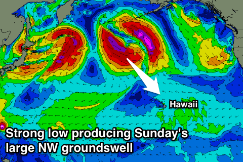
Easing surf ahead of a large NW groundswell Sunday
Hawaii North Shore forecast by Craig Brokensha (issued Thursday 22nd December)
Best Days: North Shore Thursday, Friday, Sunday and Monday for experienced surfers, Tuesday and Wednesday, PNG from Saturday
This week and next (Dec 22 – Dec 30)
Hawaii: A good N/NW groundswell is currently breaking across the region and we should see this swell starting to ease back from round 6ft on the sets tomorrow morning, if not for the odd cleanup at swell magnets.
 The easing trend will continue to ease through Friday and Saturday under fresh E/NE trades ahead of a large and powerful NW groundswell for Sunday.
The low thats forecast to generate this swell is now due to develop closer to us, resulting in the swell arriving early Sunday morning and offering a touch more size than predicted on Tuesday.
A fetch of severe-gale to storm-force NW winds will be generated through our swell window, with a large long-period NW groundswell expected to build rapidly through Sunday, reaching 10-12ft through the late afternoon.
A steady drop in size is then expected Monday from the 8ft range, smaller Tuesday morning.
Our small reinforcing NW groundswell for Wednesday is still on track, with a less than favourably aligned fetch of W/SW gales kicking the North Shore back to 4-6ft into the afternoon, fading Wednesday.
Longer term there's nothing major on the cards besides a N/NE groundswell from an intense low forming off Alaska, but more on this next week.
North Shore Forecast Graph
North Shore WAMs
Micronesia: There's no real change to the trade-swell event due this weekend across the coast, with ENE energy due to come more from the NE from Saturday as a broad and strong fetch of E/NE winds develop more to our north this afternoon and evening.
Exposed breaks should see 4-5ft+ sets through Saturday and Sunday, easing off slowly from the same size Monday and tending back to the E/NE in direction.
Unfortunately gusty E/NE trades will persist until mid-next week before tending more variable, and with this we'll see the trade-swell really dip away.
Palikir Pass Forecast Graph
Palikir Pass WAMs
Papua New Guinea: Some new NE trade-swell is pulsing a little today and we should see 3-5ft surf through tomorrow, easing slightly Saturday before the NE swell hitting Micronesia fills in Sunday.
An increase to to 4-5ft is due Sunday afternoon, persisting through Tuesday before easing slowly from Wednesday.
Variable winds will create good conditions each morning besides tomorrow where a N'ly breeze is expected.

