Great surf developing tomorrow

North-eastern Tasmanian forecast by Craig Brokensha (issued Wednesday March 19th)
Best Days: Tomorrow (especially the afternoon), Friday morning, Tuesday
Features of the Forecast (tl;dr)
- Easing SE swell tomorrow
- Moderate sized N/NE swell building tomorrow with strengthening N/NW tending NW winds
- Easing N/NE swell Fri with a weak S/SE windswell under fresh S/SE-S winds
- W/NW winds Sat with a small S groundswell
- Possible inconsistent S/SE groundswell Tue with N/NW winds
Recap
Small, clean levels of S’ly swell eased through yesterday, while this morning started tiny but some new SE swell has since built to 2ft across the coast with sea breezes.

New SE swell this afternoon
This week and next (Mar 20 - 28)
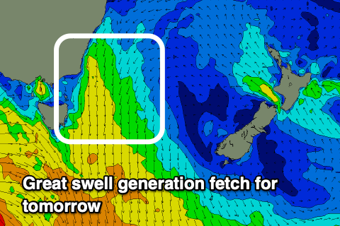
The SE pulse for this afternoon is due to ease back through tomorrow as a fun mid-period N/NE swell builds through the day, generated by an expanding fetch of strengthening N/NE winds down the coast this evening and tomorrow morning.
This should kick up building sets that should reach 4ft across the north magnets into the afternoon along with strengthening N/NW tending NW winds.
The combo of offshore wind and N/NE swell should create great waves later afternoon and into the evening, with a S/SE change into Friday morning favouring southern corners as the N/NE swell backs off from the 2-3ft range.
Into the weekend, the NE swell energy will be fading with a possible small hint of S’ly groundswell across the south magnets, generated by a strengthening low south of the state Friday.
Conditions will be clean so try the south magnets for a stray 2ft set Saturday.
Otherwise the outlook remains tiny until next Tuesday/Wednesday when we might see another good S/SE groundswell across the magnets.
The source is a flukey fetch of severe-gale to storm-force S/SE winds on the polar shelf through Friday/Saturday but we'll review this on Friday. We may see 3ft sets but check back next update.