Fun south-east followed by north-northeast

Eastern Tasmanian forecast by Craig Brokensha (issued Monday March 17th)
Best Days: This afternoon south magnets, Wednesday south magnets, Thursday northern corners, Friday morning southern corners
Features of the Forecast (tl;dr)
- Easing S/SE swell tomorrow with N/NW winds
- Inconsistent SE groundswell building Wed, peaking in the PM, easing Thu
- N/NW tending gusty N/NE winds Wed
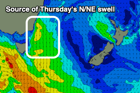
- Strengthening N/NW winds Thu with a small-mod sized increase in N/NE swell
- Easing swell Fri with SW tending E/NE winds
- Tiny weekend
Recap
The weekend was generally tiny apart from some weak swell building through yesterday, while today a better increase in S’ly swell has provided fun waves on the south magnets.
This week and weekend (Mar 18 - 23)
The current swell will ease into tomorrow as offshore winds from the north-western quadrant favour the south magnets. I wouldn’t expect much change from 1-2ft, while into Wednesday, a sneaky SE groundswell is due to arrive, generated by a low that formed south of New Zealand on the weekend.
This should build through the day and reach 2ft to possibly 3ft across the south magnets into the afternoon under a N/NW tending fresh N/NE breeze.
The swell will start to ease slowly on Thursday, mixed in with a localised, building N/NE windswell as a burst of strong N/NE winds form off the coast Wednesday evening.
North-east magnets are due to build through the day, reaching 3ft to occasionally 4ft with a N/NW offshore, strengthening through the day. A shallow SW change is due into Friday but with fading 2ft+.
Otherwise the outlook is slow for the weekend with tiny surf due thanks to an active westerly storm track and no real south energy for our region. More on this Wednesday.