Minimal surf possibilities
Eastern Tasmania Surf Forecast by Craig Brokensha (issued Friday 30th July)
Best Days: No good days
Features of the Forecast (tl;dr)
- Tiny N/NE windswell tomorrow with strong N/NW winds, tending NW later
- Small NE pulse Tue with N tending SE winds
Recap
Following Wednesday's acute N/NE swell, there's been nothing of note across the region.
This weekend and next week (Jul 31 – Aug 6)
Currently we've got strengthening N/NW winds down the coast as a vigorous cold front approaches from the west, with the winds due to swing a bit more N'ly overnight.
While this is favourable there'll be no depth to the fetch and it will be short-lived with only a tiny 1-1.5ft wave due tomorrow across the north-east facing beaches. Conditions will be poor in these spots with a strong N/NW-N breeze, tending more NW later in the day.
 Come Sunday when straighter offshore winds are due there'll be no size left with micro amounts of swell lapping the shore.
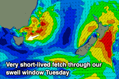
Into Tuesday there's a very flukey source of NE swell that will develop as a very brief fetch of strengthening NE winds are aimed into us ahead of a front pushing off the southern NSW coast. It's only likely to reach 1-2ft max through the day and N/NW tending SE winds, not ideal.
A weak S'ly windswell will be generated on the backside of this front/low but to no size.
Longer term three’s still nothing major on the cards for us, and the South Arm looks to offer minimal surf prospects as well. Check back Monday for any update and have a great weekend!

