Smallish N/NE windswell next week followed by S swell
Eastern Tasmania Surf Forecast by Craig Brokensha (issued Friday 21st May)
Best Days: Wednesday, later next week onwards
Features of the Forecast (tl;dr)
- Weak, building N/NE windswell late Mon, more so Tue and best Wed AM when winds start to swing offshore
- Follow up S-S/SE swell mid-late week.
Recap
Nothing of note yesterday or today.
This weekend and next week (May 22 - 28)
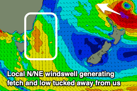
The surf will remain tiny to flat on the weekend but we do have more potential into next week with a N/NE windswell due to develop through late Monday, build further Tuesday and likely peak early Wednesday.
A slow moving but strengthening mid-latitude low pushing east through the Bight will squeeze a strong high in the Tasman Sea, bringing strengthen N/NE winds that will develop slowly through Monday, strengthen a little Tuesday but be broadest and strongest Tuesday evening.
 This will see the swell building to a weak 2ft late Monday with Tuesday seeing 2-3ft surf, best Wednesday morning with sets more to 3ft and with a bit more strength.
Winds will swing from W/NW to fresh N/NE Monday afternoon, stronger N/NW tending N on Tuesday and then N/NW tending W/SW on Wednesday as the low pushes across the state and east. This looks to be the pick for the most size and best conditions.
Now, in the wake of this change we may see the low turn into a broad, powerful system in the southern Tasman Sea, bringing a sizey S-S/SE swell for late next week and the following weekend. We'll have to have a closer look at this on Monday.
One other swell source worth mentioning is a strong low forming right off the North Island of New Zealand. This will unfortunately be tucked away too far in the swell shadow of the North Island and isn't expected to offer much in the way of swell. More on this Monday though, have a great weekend!

