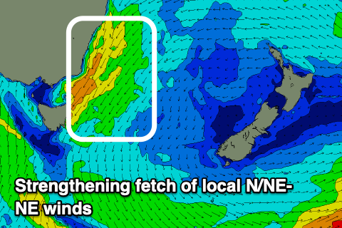
Building surf, large early-mid next week
Eastern Tasmania Surf Forecast by Craig Brokensha (issued Friday 19th March)
Best Days: Northern corners Tuesday and then when the change hits
Features of the Forecast (tl;dr)
- Slow increase in E/NE swell energy over the coming days, with some larger NE swell developing later Mon and more so Tue
- Strengthening onshore E tending E/NE and then NE winds ahead of a change likely Wed/Thu AM
Recap
A slow increase in weak swell out of the north-east, 1-2ft yesterday and today.
This week and next (Mar 20 - 26)
As discussed in Wednesday's notes, the swell will slowly strengthen and increase in size over the coming days as better levels of E/NE swell spreads down from a sustained fetch of strong E'ly winds through the northern Tasman Sea.
The surf is large across the northern NSW coast and we'll see the trough bringing the torrential rain and large surf moving slowly south over the weekend as the high in the Tasman moves east.
 This should see the fetch directed downwards, more through our north-eastern swell window, but the largest increase in size is due early next week when the trough makes it down to us, projecting strong to near gale-force NE winds directly into us.
So for the weekend we should see mostly but slightly stronger 2ft sets across open beaches, with the odd 3ft'er at times, both Saturday and Sunday. Conditions will unfortunately be average tomorrow with a freshening E tending E/NE breeze, strengthening from the E/NE on Sunday. So all in all not too attractive.
Into Monday we'll see winds strengthen further from the NE kicking up more size with building surf from 3ft in the morning towards 4ft+ later, with Tuesday seeing the peak in size with stormy 6ft+ waves developing.
Winds look to almost reach gale-force so it'll be protected northern corners only.
Now, the timing of a change is still up for grabs with GFS having it earlier than EC so we'll have to keep an eye on this and provide an update on Monday on when the surf should clean up inside southern corners.
At the earliest it looks Wednesday morning and the latest Thursday morning. Longer term the outlook is a little unsure depending on the timing of the change, so check back here Monday. Have a great weekend!

