Attention turns to the north-east
Eastern Tasmania Surf Forecast by Craig Brokensha (issued Monday 25th January)
Best Days: Souther corners tomorrow from late morning, northern corners late Friday and Saturday, southern corners Sunday
Features of the Forecast (tl;dr)
- Building N/NE swell tomorrow with varying S-SE changes
- S windswell Wednesday but with strong S/SW tending S/SE winds
- Building N/NE windswell Fri with onshore winds, peaking Sat AM with fresh N/NE tending N/NW winds
- Easing N/NE swell Sun with S/SE winds
Recap
A small S'ly swell for Saturday morning with 1-2ft waves and clean conditions, while some stronger energy filled in later through the day. Sunday offered more size with favourable conditions, fun again today with a mix of N/NE windswell and S'ly groundswell.
This week and weekend (Jan 26 - 31)
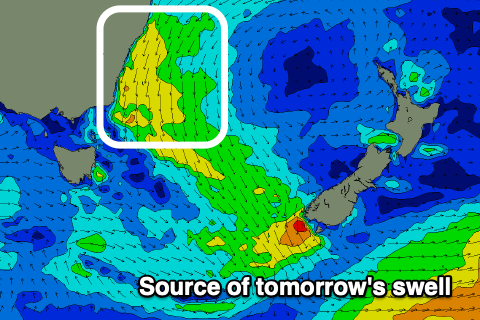
 We've got a fun pulse of N/NE windswell tomorrow, peaking through the middle of the day/afternoon from a strengthening fetch of healthy N/NE winds off the southern NSW coast this evening.
The swell should kick to 2ft to nearly 3ft across the north-east magnets tomorrow and winds will shift from the NW to S/SE late morning, favouring those southern corners. We'll likely see these winds go more E after the initial change and then SE again on dark, so try and work the timings.
This change will be linked to a small trough/low moving in from the west, with a brief fetch of strong S/SW winds due to be forecast up past us. This will then be followed by an additional fetch of strong S'ly winds towards New Zealand, helping to generate some reinforcing S/SE swell into Thursday after the initial spike in S'ly windswell Wednesday.
Size wise, south magnets should see 3ft surf Wednesday though with strong S/SW tending S/SE winds. Thursday will be poor with SE tending E/SE winds.
We then look at the deepening inland surface trough that will drift south-west from Victoria, then push east towards us on Friday.
As this does so, it will squeeze a high in the Tasman Sea, generating a fetch of strengthening and persistent NE winds through our swell window Friday and Saturday morning before the trough pushes further east and winds swing offshore.
 A building N/NE windswell will be seen Friday, reaching 4ft by dark but with strong E/NE tending NE winds, peaking Saturday morning to 4-5ft. Winds should swing from the N/NE in the morning around to the N/NW later in the day, with a S'ly change due overnight.
Therefore Sunday looks the cleanest but the swell will be fading back from 2-3ft or so.
Following these developments we've got some interesting tropical swells sources to keep an eye on. The main feature is a tropical cyclone drifting south into a great trade-flow north of New Zealand this weekend, generating a good E/NE groundswell mid-next week. More on this in the coming updates though.

