Good N/NE swell on the way
Eastern Tasmania Surf Forecast by Craig Brokensha (issued Friday 25th December)
Best Days: Tomorrow morning, Sunday northern corners, Monday
Features of the Forecast (tl;dr)
- Building N/NE windswell tomorrow afternoon, peaking Sun, easing Mon with a SW change
Recap
The large swell from earlier in the week continued to ease through yesterday with clean, fun 2ft leftovers on the coast. Today a very inconsistent E/NE groundswell from Tropical Cyclone Yasa should be in the water offering fun sets for the patient.
This weekend and next week (Dec 26 – Jan 1)
Any swell seen from Tropical Cyclone Yasa today is expected to fade tomorrow, easing from 2ft or so hrough the morning along with a W/NW offshore. From the afternoon a strengthening N/NE wind will bring with it a quick jump in localised windswell, reaching 2-3ft by dark and bigger into Sunday.
 This will be linked to a strengthening cold front approaching from the south-west, squeezing a strong high in the Tasman Sea.
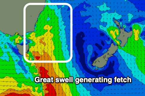
Strengthening, broadening and lengthening N/NE winds will develop through our swell window Saturday afternoon through Sunday, with the swell due to come in at 3-4ft Sunday, if not for the odd bigger lump through the afternoon as the fetch matures.
Winds will be strong from the N/NW tending N/NE so northern corners will be best.
Into Monday the front will push through bringing a light SW wind ahead of NE sea breezes and easing 3ft+ sets from the N/NE.
The swell will be all but gone Tuesday with maybe 1-2ft leftovers for the desperate.
For the rest of the week, weak troughy weather doesn't look to generate anything too significant size wise, but we should see 2ft waves out of the E/NE through the mid-end of the week, with more potential from next weekend.
More on this Monday, Merry Christmas!

