Inconsistent E/NE swell followed by consistent N/NE
Eastern Tasmania Surf Forecast by Craig Brokensha (issued Wednesday 23rd December)
Best Days: Thursday, Friday and Saturday mornings for the patient, Sunday northern corners, Monday south corners
Features of the Forecast (tl;dr)
- Inconsistent, flukey E/NE cyclone swell for Thu/Fri/Sat AM
- Good N/NE windswell Sun, cleanest Mon while easing
Recap
Building, onshore stormy surf through yesterday, very solid into the late afternoon and evening as a complex trough/low deepened to our north-east. This low drifted east last night, cutting off the infeed of E/NE winds, swinging winds locally offshore along with easing surf from 4-6ft this morning.
This week and weekend (Dec 24 - 27)
The current swell will drop out steadily this afternoon and overnight with the low linked to it pushing out of our swell window last night. There isn't expected to be any size left with fading, inconsistent 2ft sets.
We then look to the tricky, inconsistent E/NE groundswell from Severe Tropical Cyclone Yasa.
Yasa projected slowly towards us in our far swell window from Sunday through yesterday morning, with an increase in swell due tomorrow though we may see a slightly more reliable increase Friday.
Size wise, very infrequent 2-3ft sets are due, easing from this size Saturday. It'll be pulsey and at times flat for extended periods, so patience is the key.
Conditions will be cleanest in the mornings with a SW offshore tomorrow, giving into NE sea breezes and then SE tending fresh E'ly on Friday. Come Saturday W/NW winds will swing stronger N/NE into the afternoon with a healthy N/NE windswell now on the cards for Sunday.
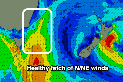
 The source of the windswell will be a strong cold front squeezing a high in the Tasman Sea, generating strengthening and broadening N/NE winds through our swell window Saturday evening and Sunday.
North facing beaches should reach 3-4ft Sunday but with N/NW winds, strong at times through the day. So northern corners will be cleanest but also smallest. A SW change Monday will create great conditions across southern corners with easing 3ft sets from the N/NE.
Longer term we may see a decent run of E'ly trade-swell as a high moves into the southern Tasman Sea, squeezed by tropical activity on its northern flank, but more on this Friday. Have a Merry and safe Christmas!

