Upgrade
Eastern Tasmania Surf Forecast by Craig Brokensha (issued Monday 21st October)
Best Days: Thursday
Features of the Forecast (tl;dr)
- Signficant upgrade in stormy E/NE swell for tomorrow, clean and easing Wed
- Inconsistent cyclone swell late week
Recap
A drop in swell from Friday with small sets out of the east-northeast coming in at an infrequent 2ft with less than favourable winds.
Today a local windswell is keeping the surf around 1-2ft with a light morning S’ly breeze.
This week and weekend (Oct 22 - 26)
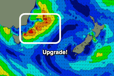
There’s been a significant upgrade in the swell potential for the coming days as a surface trough sitting to our north deepens this evening and tomorrow.
 This will project a fetch of strong to gale-force E/NE winds into us tomorrow, kicking up a rapid increase in stormy E/NE swell, reaching 6ft+ into the afternoon, if not a touch bigger on dark. Conditions will be poor though with strong E’ly tending E/SE winds are aimed into us.
The trough is due to form a low and push east with winds swinging offshore into Wednesday along with a large, rapidly easing E/NE swell. Open beaches should still see 6ft to possibly 8ft sets, dropping back to 4ft into the afternoon with a NW wind ahead of a shallow SE change late morning.
Come Thursday we’ll then be looking at the tricky, and inconsistent E/NE groundswell from Severe Tropical Cyclone Yasa.
Overall, the swell prospects from Yasa have been downgraded, with it sitting in our far swell window and being fairly weak in structure.
In saying this we’re seeing a small, stationary fetch of strong E/NE winds aimed towards us, with gale-force core winds, and this should produce some inconsistent E/NE groundswell for late week.
The timing is a little tricky but we should see infrequent 3ft sets from sometime Thursday through Friday, then easing Saturday. Thursday morning looks in between swell pulses and to 2-3ft.
Winds look SW Thursday morning ahead of N/NE sea breezes, possibly SE later then then W/SW tending E/SE winds Friday.
Into the weekend NW to N/NE winds look to add an additional N/NE windswell to the mix, but more on this Wednesday.

