Small, mixed weekend, infrequent cyclone swell next week
Eastern Tasmania Surf Forecast by Craig Brokensha (issued Friday 18th October)
Best Days: Saturday morning, Thursday morning, Friday southern corners
Features of the Forecast (tl;dr)
- Fading N/NE energy with tiny, weak E/NE windswell building Sun, peaking Mon
- Inconsistent, small E/NE energy from Severe Tropical Cyclone Yasa Thu-Fri
Recap
A fun mix of E/SE and building N/NE swells yesterday, best in southern corners, with the N/NE swell being the more dominant today with variable winds.
This weekend and week (Oct 19 - 24)
Today’s N/NE swell will fade through the weekend owing to the swell generating fetch linked to it retracting north-east, away from our swell window last night and this morning.
We should still see the odd 2ft set tomorrow morning, while background levels of inconsistent E/NE trade-swell will likely keep 1-2ft sets hitting open beaches through Sunday-Tuesday.
Winds will be favourable for southern corners tomorrow morning with a SW breeze, quickly swinging S’ly and then SE into the afternoon as a trough pushes up the coast.
 This trough is then due to linger off our coast Sunday/Monday, aiming weak E/NE winds into us, but windswelly wise, nothing over 2ft is due later Sunday/Monday and with onshore winds.
Come Tuesday lighter winds are expected but with 1-2ft leftovers.
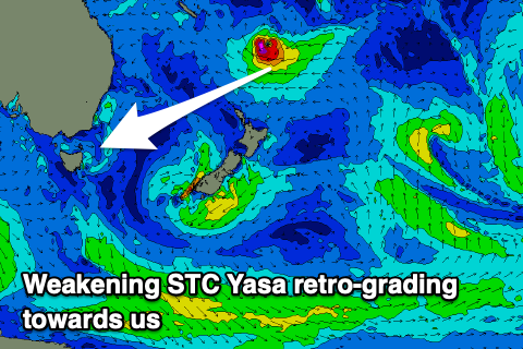
We then look to the tricky swell from Severe Tropical Cyclone Yasa. Yasa moved across Fiji as a Category 5 system but luckily relatively quickly, though it still caused widespread damage.
Overall the swell potential from Yasa has been downgraded with it dropping south-southeast, slightly away from our swell window tomorrow, generating significant though not overly well aimed E/SE winds.
Yasa is forecast to retro-grade (swing back south-west) towards us Sunday and Monday before breaking down Tuesday. This is positive for generating swell, with it moving closer towards us and on a positive track and this will likely provide the best pulse of swell later week.
The inconsistent NE groundswell energy from this evening and tomorrow is expected to arrive Wednesday, but unlikely to offer much over 2ft. The better E/NE pulse from the retro-grade is expected Thursday and Friday with sets to 3-4ft, though with a long wait for them.
Winds look favourable with morning offshores at this stage, though giving into a S/SE change Friday, but more on this Monday. Have a great weekend!

