Dynamic period with tropical swells inbound
North-east Tasmania Surf Forecast by Craig Brokensha (issued Monday 14th October)
Best Days: Thursday
Recap
Generally small waves for the keen on the weekend, out of the south Saturday and then a mix of south and north-east yesterday. Today we’ve got building levels of north-easterly swell with more to come.
This week and weekend (Oct 15 - 20)
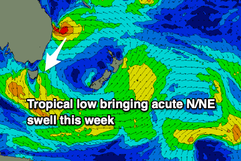
Looking at the current synoptic setup and we’ve got a strong high in the Tasman being squeezed by a tropical low on its northern flank, bringing flooding rains and large, stormy surf to Qld and northern NSW, while down towards us a more localised and weaker fetch of strong N/NE winds is kicking up some weaker windswell.
 The low is expected to weaken as the high moves slowly east this afternoon and evening, allowing a fetch of strong to gale-force NE to move into our swell window, before weakening all together tomorrow.
The low ended up sitting further north and for longer than forecast on Friday so the swell from the N/NE isn’t expected until Wednesday now with it peaking through the morning.
So for tomorrow we'll be looking at more localised N/NE swell to 3ft+ across north-east facing beaches but with N/NW-N/NE winds ahead of a late S-S/SE change. This change should impact the whole coast before dark, so this is the pick of the day tomorrow for southern corners.
S tending S/SE winds will persist Wednesday, shifting more SE later along with that acute and stronger N/NE groundswell. It’ll be inconsistent but we should see strong 4ft sets on those north facing beaches, if not for the rare sneaky bigger bomb, easing into the afternoon and then down from 3ft to possibly 4ft Thursday morning.
All other locations will be much smaller, so keep this in mind. Conditions on Thursday may start out dicey with a SE breeze but a small trough will likely see winds shift more S/SW through the morning, creating improving conditions, holding from the S/SW Friday as the swell eased back further to 2ft.
Moving into the weekend and small, weak swells are likely with a trough to our east possibly producing a small E’ly windswell for later Sunday/Monday but it’s the developments in the Coral Sea that look to bring our next decent groundswell.
 Tropical Cyclone Yasa has been named and is sitting between Vanuatu and Fiji, with it expected to deepen into a Severe Tropical Cyclone during this week while staying relatively stationary.
Come Friday it’s forecast to drift south and squeeze the northern flank of the high generating our current swell, with a tight but significant fetch of gale to severe-gales due to be generated in our north-eastern swell window.
We should see a long-period and inconsistent swell from TC Yasa next week, arriving Wednesday/Thursday and likely reaching 4-5ft. We’ll provide more updates on this distant swell Wednesday and Friday though.

