Small, tricky weekend, more reliable next week
Eastern Tasmania Surf Forecast by Craig Brokensha (issued Friday 11th December)
Best Days: South swell magnets tomorrow and later Sunday, north facing spots later Tuesday, Wednesday and Thursday
Recap
Small pulses of acute S'ly swell building through yesterday but with average winds, cleaner this morning but easing and on the small side. A fresh pulse of S'ly swell is due this afternoon to 2-3ft on the south magnets but with average conditions.
This weekend and next week (Dec 12 - 18)
A broad polar front that's currently pushing up towards New Zealand, past the south-east corner of the state is responsible for later today's swell, with it due to ease back from 2-3ft tomorrow morning.
Conditions are a little dicey for the south magnets again with a light variable SW wind at dawn, shifting E/SE through the morning and better out of the N/NE into the afternoon.
A low point in swell is expected Sunday morning to 1-2ft, ahead of a tricky new S'ly groundswell into the afternoon. This will be along with a building N/NE windswell, but coming back to the S'ly groundswell source, and it's actually a fetch of severe-gale NW winds that formed around a low south-west of Western Australia.
This sounds weird but because of the Earth's curvature, this is actually aimed in our swell window. We should see the swell kicking later Sunday and reaching 2ft to possibly 3ft on the south magnets (inconsistent) along with strengthening N/NE winds.
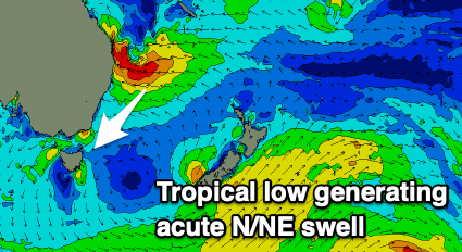
Now, these strengthening winds will be linked to a strong high moving into the Tasman Sea, squeezed by a tropical low forming in the Coral Sea. The low will continue to deepen while moving closer to the East Coast, weakening once being aimed directly at us.
 What we'll see is a building local N/NE windswell from strengthening N/NE winds east and north of us though no major size is due from this. North-east facing beaches may reach 2ft late Sunday and build further to 2-3ft through Monday afternoon.
It's into Tuesday and Wednesday that we should see a bit more size with the windswell to 3ft Tuesday morning ahead of an acute pulse of N/NE groundswell through the afternoon from the low proper.
Size wise, north facing beaches should kick to 4-5ft through the late afternoon/evening, easing back from a similar size Wednesday morning.
Locally winds will be fresh to strong from the N/NE, lighter and N/NW early Monday and Tuesday mornings, with a S'ly change likely near dark Tuesday. This should great great waves with the mix of N/NE windswell and building groundswell.
S/SE winds will then favour southern corners Wednesday as the swell eases.
This won't be the end of the swell though, with a severe Tropical Cyclone due to form between Fiji and Vanuatu through Monday, drifting slowly south generating additional but less consistent levels of NE trade-swell followed by a possible secondary groundswell. More on this Monday though. Have a great weekend!


Comments
Can't seem to find any waves down this way. Been from Bicheno to South Arm.
With the swell being so weak this morning/early afternoon and angled to the north-east, your best chance is more north of Bicheno (which is quite sheltered from south swells.)
There's the slightly stronger pulse later today that should perform better, but it's nothing special. Swells from this part of the swell window and alignment are flukey.