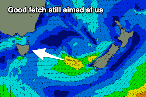
Slow drop in easterly energy
Eastern Tasmania Surf Forecast by Craig Brokensha (issued Monday 26th October)
Best Days: Tomorrow, Friday, Saturday morning in protected spots
Recap
A fun kick in S/SE swell yesterday, best in protected spots while our larger E'ly swell for today seems to be under reported.
The closest buoy available in Eden, southern NSW is still holding around 2.8m with peak periods hovering around 9-10s and this should be resulting in more than 2-3ft.
This week and weekend (Oct 27 – Nov 1)
The swell seen through today will slowly ease into the end of the week as conditions improve, with the longevity of the swell being helped by a fetch of strong E/SE winds that are still being generated in the southern Tasman Sea.
Size wise, open beaches should ease back from the 4ft range, smaller into Friday but holding around 2-3ft as a reinforcing pulse of E/SE swell fills in from a burst of E/SE winds off the southern tip of New Zealand.
 Saturday should then ease back from 2-3ft.
Looking at the local winds and a light SW'ly is expected early tomorrow, quickly shifting S'ly and then SE with a trough off the coast. The afternoon looks bumpy with E winds.
Friday looks to play out similar, cleanest early, with S tending NE winds on Saturday.
A trough moving off the southern NSW coast on the weekend, touched on in Monday's notes now looks to generate some small E/NE swell for Sunday/Monday, with a weak fetch of E/NE winds sitting in our swell window on its southern flank.
This may generate a small 2ft+ of swell, easing into next week but we'll review this again on Friday.

