Building easterly energy though watch those winds
Eastern Tasmania Surf Forecast by Craig Brokensha (issued Monday 26th October)
Best Days: Protected spots later tomorrow and Wednesday, Thursday morning, Friday morning
Recap
A tiny N/NE windswell to start the weekend, followed by a building S'ly swell yesterday which is hanging in today but with favourable winds for protected locations.
This week and weekend (Oct 27 – Nov 1)
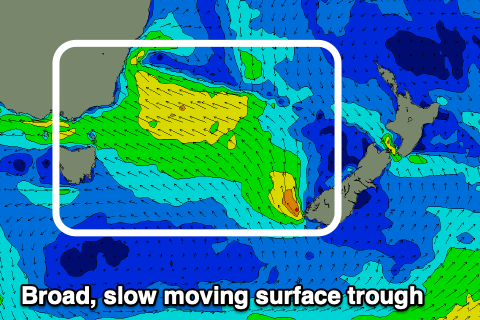
We've got a very active week of surf ahead with a strong surface trough that's deepened off the southern NSW coast due to drift south and broaden over the coming days, squeezing a strong high that's currently south-west of the state. The trough should linger in our swell window until Thursday.
 Currently strong to gale-force SE winds are being aimed into southern NSW, producing large, stormy surf, but this afternoon and evening we'll see the trough drift south, swinging a broad fetch of strong E/SE winds into our swell window.
The slow movement of the trough will see the winds acting on top an active sea state, helping to increase the size of the expected swell.
We'll see strong onshore SE winds but building surf out of the E tomorrow afternoon with the morning coming in around a weak 3ft or so. The afternoon should pulse to 4ft+ or so, but the peak in size is due Wednesday with solid 4-6ft surf.
Winds will unfortunately remain onshore out of the SE on Wednesday, finally improving and swinging SW on Thursday morning.
This will be as the trough weakens and we should see great easing 4-5ft sets, down further Friday from 3ft+.
Winds are due to shift E/SE Thursday afternoon, followed by SW tending S/SE-SE winds Friday as another trough moves in from the west.
This trough doesn't look too healthy for swell generation at this stage with a weak S'ly windswell on the cards for Saturday/Sunday but we'll have a closer look at this Wednesday.

