Tricky south followed by more reliable north
Eastern Tasmania Surf Forecast by Craig Brokensha (issued Monday 14th September)
Best Days: South magnets tomorrow and Wednesday morning, south swell magnets Saturday, Sunday morning, Monday morning
Recap
Tiny and generally unsurfable waves on the weekend just past, though south magnets may have offered something Saturday afternoon.
Today remains tiny but a beautiful day.
This week and weekend (Sep 15 - 20)
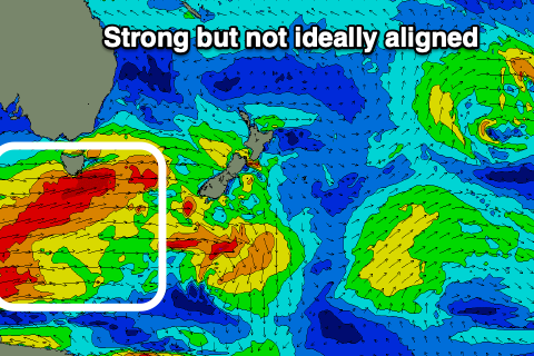
Looking at the coming week and we've got tricky pulses of S'ly groundswell due, with the frontal progression that's currently moving under us now not expected to project as favourably into the Tasman Sea or with any major strength.
This will reduce the expected size, and the angle will be more west than ideal, resulting in less consistency as well.
 A burst of gale to severe-gale W/SW winds pushing past is this afternoon should produce a small pulse of S'ly swell for the northern end of the coast tomorrw to 2-3ft across south swell magnets, then easing Wednesday from what looks to be a similar size.
All other beaches will be tiny to flat and expect the sets on these south magnets to be inconsistent.
Following this the storm track looks unfavourably aligned and weaker, with tiny surf to end out the week.
Conditions should be favourable for these south magnets tomorrow with a NW-W/NW breeze, possibly variable into the afternoon across some locations, NW all day Wednesday.
Thursday will be poor as a trough moves up the coast bringing fresh to strong S-S/SE winds and a poor, local windswell.
 Into Saturday a small, new S'ly groundswell should be seen, originating from a slightly better source than tomorrow's.
A more polar fetch of W'ly gales moving in late week should produce a fun 2-3ft of S'ly swell for Saturday, fading Sunday. Also in the mix will be some building N/NE windswell from a trough slipping down the southern NSW coast, squeezing a high in the Tasman Sea.
This looks to become a stationary feature into Sunday and early next week with building levels of persistent N/NE swell due, likely coming in around 3ft or so with favourable morning winds, but we'll have a closer look at this on Wednesday.

