Small, weak N/NE swells
Eastern Tasmania Surf Forecast by Craig Brokensha (issued Monday 7th September)
Best Days: Later tomorrow and early Wednesday north swell magnets
Recap
Tiny, weak waves out of the NE Saturday, then S/SE on Sunday.
Today we should be seeing some new weak N/NE windswell building, best tomorrow and discussed below.
This week and weekend (Sep 8 - 13)
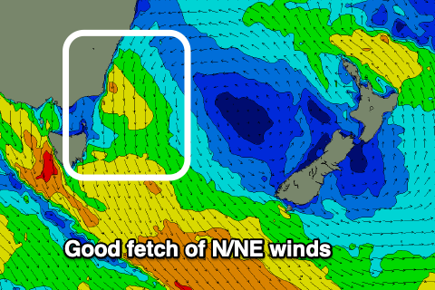
An approaching mid-latitude front from the west is squeezing a high in the Tasman Sea and we're seeing a strengthening and broadening fetch of N/NE winds developing through our swell window.
This fetch looks to reach maturity through this evening and early tomorrow morning just east of Bass Strait, with the swell expected to peak through the day across our north-east swell magnets.
 Building surf to 2ft to occasionally 3ft should be seen across the north-east swell magnets as winds shift from N-N/NW to NW-W/NW into the afternoon, SW across the southern end of the coast.
Therefore the late surf across north-east swell magnets looks the go, with Wednesday easing from 1-2ft with a W/SW tending SE breeze.
The change linked to the swing in winds on Wednesday doesn't hold any strength any more and we'll see it in the form of a trough, sliding up the southern NSW coast as another high moves into the Tasman Sea.
A good fetch of easterly winds are expected to be generated on the northern flank of the high, but too north of our swell window to generate any swell for our regions into Thursday/Friday.
Instead weak N/NE winds developing in our north-eastern swell window again on the weekend looks to produce some small to tiny N/NE windswell though not above 1-2ft.
Longer term we may see some distant NE swell from the Coral Sea, mixed in with S'ly groundswell from the Southern Ocean, but we'll have another look at this Wednesday.


Comments
How is the swell looking today, worth a paddle ??