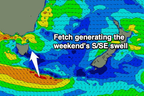
Fun run of swell from the south-southeast
Eastern Tasmania Forecast by Craig Brokensha (issued Friday 21st August)
Best Days: Saturday, Sunday, Monday, Tuesday
Recap
A drop in E/NE swell as a better S/SE swell kicked in through the day, kicking to 3-4ft with offshore winds. The swell has eased back today from 2ft+, cleanest on the south swell magnets.
This weekend and next week (Aug 22 - 28)
Yesterday afternoon's and today's S/SE swell will fade through tomorrow, but we'll see building levels of new S/SE swell from the infeed of strong SE winds on the bottom flank of a low that's formed to our south-west.
 The low is expected to shift north and move east tomorrow, bringing the fetch up and towards us, followed by strong fetch of localised S-S/SW winds on Sunday afternoon.
We should see building levels of S/SE swell tomorrow, peaking Sunday morning with a S'ly pulse Monday.
Tomorrow morning should start around 2-3ft on the sets, building later in the day to 4ft or so, with Sunday seeing 4-5ft+ sets.
The S'ly swell Monday looks a similar size, though smaller in protected spots due to the swing in direction, easing into the afternoon and then down further Tuesday.
Conditions tomorrow morning will be clean with a W/SW breeze, strengthening from the S'th through the day and then strong SW tending S/SW on Sunday.
Winds should ease a touch Monday and go from SW to S again, with W'ly offshores on Tuesday, variable through the afternoon.
Longer term there's nothing too significant on the cards so make the most of the coming run of swells. Have a great weekend!

