Large run of swell from the east
Eastern Tasmania Surf Forecast by Craig Brokensha (issued Monday 13th July)
Best Days: Southern corners Wednesday and Thursday, Friday, Saturday, Sunday
Recap
A tiny hint of S'ly swell Saturday and then poor conditions yesterday with some small S'ly swell to 1-2ft today.
This week and weekend (Jul 14 – 19)
These notes will be brief as Ben's on annual leave.
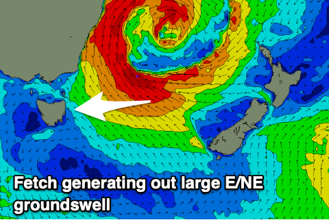
Now that the weekend's out of the way we look to our large run of E'ly swell due from a 'bombing low' in the Tasman Sea.
 The ingredients for this system are all coming together, with a drifting upper cold pool, surface instability and upper level supporting ridge.
This will lay the foundations of a rapidly deepening low in the Tasman Sea over the coming 24 hours, so much so that it'll be qualified as a 'bombing low', dropping over 24hPa in central pressure in 24hrs.
What we're seeing currently is a broadening and strengthening fetch of E/SE winds on the southern flank of the deepening trough and this will generate a building E'ly swell tomorrow, but as the low 'bombs' it will drift slightly south opening us up our swell window to a fetch of gale-force E/SE winds, with embedded stronger bursts.
This will produce a large pulse of building E/NE groundswell for Wednesday, but coming back to tomorrow and building surf from 2-3ft across open beaches is expected, reaching 3-4ft later in the day.
Wednesday should see a rapid uptick in size as the E/NE groundswell fills in, kicking to 6ft to occasionally 8ft through the afternoon (smaller and to 4-5ft early), and then holding a similar size Thursday as the low continues to aim strong to gale-force E/SE winds towards us through Tuesday evening and Wednesday.
We'll see this fetch start to weaken into Thursday but at the same time a secondary fetch of E'ly gales will develop off New Zealand's North Island Wednesday evening and persist Thursday, generating a reinforcing pulse of E/NE groundswell for Saturday.
Size wise Friday will likely only ease slightly back to 5-6ft, with Saturday maintaining this size through most of the day, only easing later and then down from 3-5ft on Sunday, all but gone Monday.
Now, coming back to the local winds and with the low deepening and drifting south we'll see S'ly tending stronger S/SE winds tomorrow, persisting out of the S/SE Wednesday, favouring southern corners.
Come Thursday we'll start to see conditions improve, with winds swinging S/SW through the morning, though back to the S/SE into the afternoon.
Friday looks excellent with W'ly offshores ahead of N/NE sea breezes and then NW tending fresh N/NW winds Saturday, similar and possibly stronger Sunday.
Longer term another weak low may form off our coast early next week, or otherwise just push up as a weak front. More on this and any changes to the outlook Wednesday.

