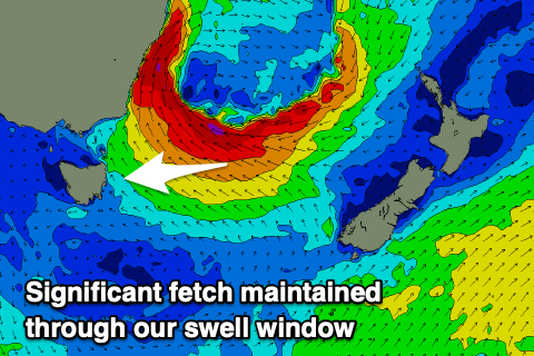
Large, windy and prolonged easterly swell event
Eastern Tasmania Surf Forecast by Craig Brokensha (issued Friday 10th July)
Best Days: South swell magnets for the desperate tomorrow morning, southern corners Tuesday and Wednesday, Thursday onwards
Recap
Small easing sets from 2ft across the south swell magnets yesterday, 1.5ft today.
This weekend and next week (Jul 11 - 17)
There's likely to still be a tiny hint of S'ly swell tomorrow but only to 1-2ft max on the south swell magnets and with W'ly offshore winds ahead of a shallow SE change.
Sunday looks poor as we see the low in the Tasman Sea start to develop, with fresh S/SW tending S/SE winds and no major swell.
Looking more closely at the low forming off the southern NSW coast, this doesn't look to be classified as an East Coast Low as rainfall totals are significant but not over the top and coastal winds not overly strong. The low will expand quickly as well and move into the Tasman, classing it more closely to an Easterly Trough Low, or just a standard Tasman Low.
 What we'll see as the low develops though will be a great expanding fetch of strong to gale-force E/SE winds on its southern flank as it squeezes a high sitting south of our state.
This will occur during Sunday evening but more so Monday, with building levels of weaker E'ly swell likely Monday ahead of stronger groundswell energy Tuesday. The low is forecast to drift slowly south while maintaining the fetch in our swell window and this should result in a peak in size Thursday.
Looking at the sizes and building surf Monday to 2-3ft is due later in the day but with fresh and gusty S/SE winds, possibly S/SW at dawn.
From Tuesday a steady and gradual increase in size should be seen, upwards from 3-4ft to 4-5ft through the afternoon and to a larger 6-8ft Wednesday, if not for the odd larger one later in the day. Thursday should then ease from 6-8ft+, though this will only be temporary with sets not likely dropping below 4-5ft Friday.
As the low moves slowly east we'll see a re-intensification with a great fetch of E'ly gales aimed towards us later next week.
 This will produce a reinforcing and less consistent E/NE groundswell for later Friday but more so Saturday with a kick in size back to 4-6ft, dropping slowly from there into Sunday and Monday.
Coming back to the local winds and strong S/SE winds will develop into Tuesday as the low drifts south, persisting Wednesday but easing in strength and then swinging offshore from the SW on Thursday. Friday should be clean ahead of N/NE sea breezes and then N/NW winds into Saturday, swinging more NW Sunday.
We'll go over the expected sizes, timings and reinforcing swell pulses on Monday though. Have a great weekend!

