Swell from all directions this period
Eastern Tasmania Surf Forecast by Craig Brokensha (issued Monday 18th May)
Best Days: Wednesday afternoon, Friday, Sunday onwards
Recap
There should have been a fun though inconsistent E/NE swell on the coast through the weekend, though it's back to a tiny 1-1.5ft today.
This week and weekend (May 19- 24)
A small N/NE windswell wave is expected tomorrow to 1-2ft across north-east facing beaches from strengthening N/NE winds this afternoon and evening.
NW tending N/NW winds won't really favour these locations and we'll then see a broader and more significant fetch developing through Tuesday evening and Wednesday.
 This should kick up a bit more N/NE energy Wednesday to 2-3ft or so as N/NW winds strengthen and shift W/NW through the afternoon with a change. This looks the best time to surf before the swell fades later, tiny into Thursday.
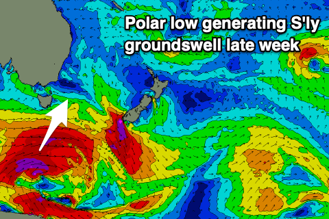
We then look at the vigorous polar low that's forecast to develop under the state mid-week.
This low will generate a great fetch of severe-gale to near storm-force W/SW-SW winds in our southern swell window as it pushes slowly east, producing a good long-period S'ly groundswell for Friday.
We should see the swell building through the day Friday and hitting 3-5ft across the south swell magnets, smaller elsewhere and with OK W/SW tending SE winds.
 The S'ly groundswell is expected to ease through Saturday but a broad low forming off the NSW South Coast is expected to drift south slowly over the weekend, with a fetch of strong S-S/SE winds due to form just to our east.
This will bring unfavourable and strong S/SW tending S winds on Saturday with a local S'ly swell but without much size or power easing out of the S/SE on Sunday with similar winds out of the S'th. Size wise, the swell from this local fetch doesn't look to top 3-4ft.
The secondary developments of this low after it weakens and broadens into early next week look a bit better with some fun E/SE swell on the cards into next week. This will also be mixed in with some distant E/NE groundswell from a stationary low above New Zealand later this week, but more on this Wednesday.

