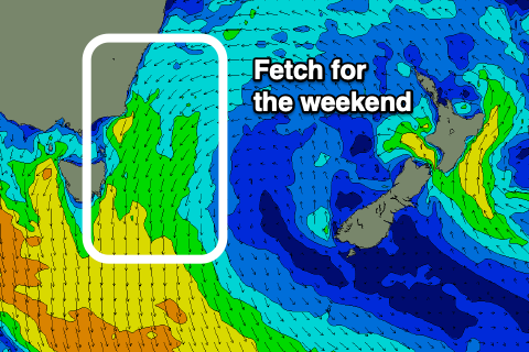
A bit more south and then more consistent north-east
Eastern Tasmania Surf Forecast by Craig Brokensha (issued Wednesday 25th March)
Best Days: South swell magnets later tomorrow, Sunday protected spots, Monday morning
Recap
A fun pulse of S'ly swell yesterday, while today is back to the small to tiny stuff.
This week and weekend (Mar 26 - 29)
We're seeing a weak cold front pushing up and past the state and this will produce a new short-range S'ly swell for tomorrow coming in at 3ft across south swell magnets, mixed in with some smaller background S'ly groundswell.
Winds are still expected to be best in the afternoon tomorrow with an average morning S/SW breeze, shifting S/SE and then around to the NE into the late afternoon.
 Friday should be clean but small and fading from 1-2ft or so on the south swell magnets with a W/NW tending NE breeze.
Moving into the weekend and one final pulse of small diffracted S'ly groundswell is due Saturday to 1-2ft on the south swell magnets, generated by a final polar front just in our southern swell window today and early tomorrow.
Some better N/NE windswell is due to build Saturday afternoon but peak Sunday with strengthen N/NE winds developing in our swell window on the weekend.
The fetch looks strongest Saturday evening and Sunday morning, kicking up sets to 3ft across the north-east magnets Sunday (possibly odd bigger one) along with workable N/NW winds.
Cleaner conditions are due Monday morning but the swell will be easing from 2-3ft.
Longer term a deepening inland trough and low drifting offshore and off our state looks to produce a new E'ly swell later week with onshore winds initially, but more on this Friday.

