Great run of swell from the north-eastern quadrant
Eastern Tasmania Surf Forecast by Craig Brokensha (issued Friday 28th June)
Best Days: Later Monday, Tuesday, Wednesday, Thursday, Friday morning, Saturday, Sunday
Recap
Tiny to flat surf the last couple of days.
Today’s Forecaster Notes are brought to you by Rip Curl
This weekend and next week (Jun 28 – Jul 5)
Lets get through the weekend's N/NE windswell event first so then we can get onto the more juicy stuff into next week.
Wednesday's update had the swell looking stronger and better, but now it's a dicey one, with a strong mid-latitude low moving in from the west, squeezing a strong high over New Zealand now due to only generate a brief fetch of strong N/NE winds in our swell window Saturday evening.
 With this tomorrow will remain mostly tiny and weak and to 1-2ft, while Sunday looks to ease from a similar size with fading 2ft sets at north-east magnets along with a NW tending W/NW breeze.
Nothing special at all unfortunately.
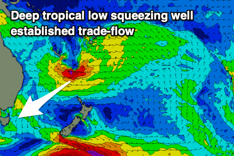
Of greater importance is the tropical low developing on top of the high, squeezing an established fetch of E'ly trades north of New Zealand.
This low has been upgraded slightly in strength and we'll see a fetch of severe-gale E'ly winds forming on a well established and active sea state in our north-eastern swell window this evening.
The fetch will remain at strength through most of tomorrow as the low moves slightly south and then weakens Sunday, swinging the trade-fetch more into our swell window and E/NE.
It looks like we'll see strong E/NE trades maintained through our distant swell window until the middle of next week, prolonging the swell event.
Now, timing and size wise, Monday will start tiny (there may be a small S groundswell in the water) but we should start to see some movement into the afternoon and evening ahead of the largest and strongest pulse on Tuesday. We should see north-east magnets coming in at 4-5ft with the odd 6ft set, easing slowly from 4-5ft Wednesday and likely not dropping below and inconsistent 3-4ft until the weekend.
Winds will be generally good with a stiff N/NW'ly Monday but better NW tending W/SW winds Tuesday as the swell proper fills in.
Wednesday will offer W'ly tending variable winds and then W/SW to S/SE winds on Thursday as a front moves up through the Tasman Sea. We'll have a closer look at the longer term outlook on Monday. Have a great weekend!

