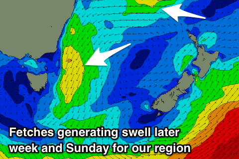
Prolonged NE swell event, slowly easing
Eastern Tasmania Surf Forecast by Craig Brokensha (issued Wednesday 17th October)
Best Days: Every day over the coming period until Tuesday
Recap
Moderate levels of NE swell the last two days, cleanest in more protected spots with winds from the north-eastern quadrant.
Today’s Forecaster Notes are brought to you by Rip Curl
This week and weekend (Oct 18 – 21)
The fetch of NE winds off our coast has relaxed into this afternoon but we'll see them pick up again off the southern NSW coast this evening and early tomorrow, producing a fresh pulse of N/NE swell energy for tomorrow, building to 4-5ft on the sets across north facing beaches, easing off slowly from Friday as the fetch pushes away from us slowly.
There'll also be some longer-range NE swell in the mix from a tropical depression sitting between Australian and New Zealand’s North Island, with that due to fill in Sunday.
But coming back to tomorrow, cleaner conditions should be seen with a W/NW tending N/NW breeze as the new N/NE swell muscles up, great and clean Friday with a persistent NW'ly and easing sets from the 4ft range.
 Saturday looks smaller with easing surf from 3ft or so and a strong front pushing across us should bring all day W/NW offshores.
Sunday's new swell should keep open beaches around 3ft, but less consistent and with a W/NW tending N/NW breeze, easing slowly early next week with a bit more north in the winds Monday, offshore Tuesday.
Longer term there's nothing to significant on the cards for the rest of next week, so make the most of the coming clean days of swell.

