Upgrade in south and north-northeast swells
Eastern Tasmania Surf Forecast by Craig Brokensha (issued Friday 20th July)
Best Days: Saturday afternoon and Sunday morning south swell magnets, Tuesday
Recap
Tiny to flat conditions the last couple of days with no decent swell.
Today’s Forecaster Notes are brought to you by Rip Curl
This weekend and next week (Jul 21 - 27)
Want to receive an email when these Forecaster Notes are updated? Then log in here and update your preferences.
We've had a further upgrade in the swell due over the weekend from Wednesday's notes, with the weakening mid-latitude low linked to it, stalling slightly as it pushes in from the west this evening.
We should see slightly stronger near-gale-force S/SW winds generated right off our coast this evening, weakening into tomorrow morning as the low moves off to the east.
 With this, south facing locations look to kick to 3ft+ tomorrow morning, easing through the day, and back further from 2ft Sunday morning.
With the low stalling slightly, winds aren't looking as favourable anymore, with a fresh SW breeze tomorrow, easing and tending more W'ly later, and then W/NW winds Sunday.
We may see a small final pulse of SE swell into Tuesday, generated by a fetch of poorly aligned S/SE gales off the tip of New Zealand's South Island as the low continues east, producing 2ft sets.
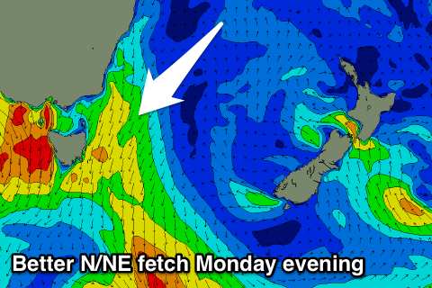
This will be hidden under a better looking N/NE windswell, with an approaching cold front squeezing a strong high in the Tasman Sea.
A better aligned fetch of strengthening and broad N/NE winds are forecast to be generated Monday evening, kicking up a fun N/NE windswell to what looks to be the 3ft range Tuesday morning, easing rapidly as the front moves through bringing a W/NW change.
Once the front pushes through there's nothing significant for the rest of the week, but more on this Monday. Have a great weekend!

