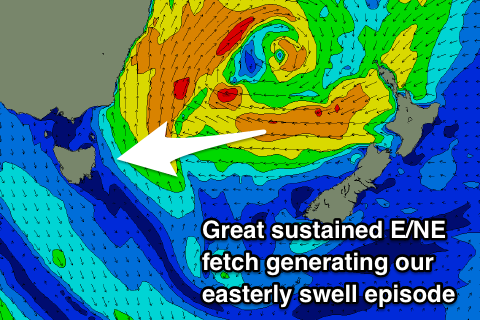
Great easterly swell episode from the weekend
Eastern Tasmania Surf Forecast by Craig Brokensha (issued Wednesday 30th May)
Best Days: Saturday onwards
Recap
A tiny weak increase in N/NE windswell yesterday, back to near northing this morning.
Today’s Forecaster Notes are brought to you by Rip Curl
This weekend and next week (May 31 – Jun 1)
Our dynamic and exciting weekend of surf is still on track, but we're now looking at more size and a later peak into early next week.
Looking at tomorrow though, and a relatively weak but strengthening trough pushing up past us should kick up an increase in S'ly windswell through the late afternoon, but I reckon we'll be lucky to see sets reaching a very weak 3ft by dark and with gusty S'ly winds.
 The swell will fade quickly overnight leaving 2ft sets max across south facing beaches, easing through the day with a W'ly tending onshore wind.
Of greater importance is the formation of a deep Tasman Low in the central Tasman Sea.
The structure of this low will see an infeed of strong to gale-force E/NE winds on its eastern flank aimed through our eastern swell window from tomorrow evening through until Sunday morning, producing moderate levels of E/NE swell.
This swell will show Sunday, but ahead of this on Saturday a SE pulse is due from a fetch of S/SE winds on the southern flank of the low tomorrow evening and Friday.
We should see building surf to 3-4ft out of the SE on Saturday, with a W'ly tending variable wind.
Come Sunday as the E/NE swell builds, open beaches should reach 4-5ft+ through the afternoon, with a peak Monday to 4-6ft, easing back slowly from Tuesday.
Winds look favourable and offshore each morning (though quickly tending S/SW Monday) with onshore breezes in the afternoons.
We'll have a closer look at this on Friday though.

