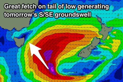
Great easing S/SE groundswell over the weekend
Eastern Tasmania Surf Forecast by Craig Brokensha (issued Friday 25th May)
Best Days: Saturday, Sunday
Recap
A temporary drop in south swell yesterday morning, though still a good 3-4ft ahead of a much stronger and large increase in S'ly groundswell through the late afternoon and evening.
This morning we saw pumping surf with the large S'ly groundswell hanging in at 6ft+ under offshore winds.
Today’s Forecaster Notes are brought to you by Rip Curl
This weekend and next week (May 26 – Jun 1)
A steady drop in size should have been seen through this afternoon across the coast, but into tomorrow a good reinforcing S/SE groundswell pulse is expected from the backside of the intense front linked to today's swell.
We should see good clean 4-5ft sets tomorrow morning, easing through the day and back from a smaller 2ft to possibly 3ft dawn Sunday.
 A light W'ly wind will give into sea breezes tomorrow afternoon, and NW tending N'th winds Sunday.
A small reinforcing S'ly groundswell to 2ft is likely Sunday as well from a polar low that's currently south of the state, with tiny waves come Monday.
There's nothing major on the cards for early next week, with a tiny N/NE windswell signal Monday and more so Tuesday morning but not above 1-1.5ft.
Of greater importance is the possible formation of a deep Tasman Low off the southern NSW coast later next week and into the weekend.
A S'ly change will bring an increase in average windswell Thursday afternoon/Friday morning, with some possible good E/SE swell from the bottom of the low into next weekend if it develops.
More on this Monday though. Have a great weekend!

