Large south swell building tomorrow afternoon, cleaner and easing Friday
Eastern Tasmania Surf Forecast by Craig Brokensha (issued Wednesday 23rd May)
Best Days: Thursday afternoon protected spots, Friday, Saturday, Sunday morning
Recap
Building S'ly swell through yesterday, small in the morning to 2-3ft, larger but bumpy into the afternoon, while this morning the groundswell was still strong with offshore winds.
Today’s Forecaster Notes are brought to you by Rip Curl
This week and weekend (May 24 – 27)
Today's S'ly groundswell should of eased into this afternoon and will hit a low point tomorrow morning ahead of a secondary large long-period S'ly groundswell into the afternoon and Friday.
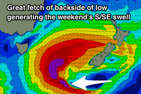
Currently a vigorous polar low is south-west of us, generating a fetch of severe-gale to storm-force W/SW winds just out of our swell window.
We'll see this system move east and into our swell window this afternoon and evening, projecting a fetch of storm-force SW winds up and into the Tasman Sea, with a trailing S/SE fetch of gales on its tail tomorrow afternoon.
 This will generate one the of the largest swells in recent history for Fiji this coming Sunday/Monday, but we'll see large long-period S'ly groundswell spreading radially into us from tomorrow afternoon, kicking to an easy 6ft across south magnets, with Friday morning likely easing from 6ft to possibly 8ft.
The S/SE fetch should then generate some reinforcing S/SE swell as the S'ly energy fades Friday afternoon, with Saturday morning dropping from 4-5ft.
Now winds tomorrow look less than ideal with a W/SW tending SW-S/SW breeze, much better Friday for south magnets with a W/NW tending NW breeze. Saturday also looks great with a NW tending N/NE breeze.
Into Sunday the SE swell will be smaller and easing from 2ft to maybe 3ft, with offshore N/NW winds.
Longer term there's nothing too significant on the cards at this stage besides a small NE windswell. More on this Friday.

