Large stormy SE swell Friday/Saturday
Eastern Tasmania Surf Forecast by Craig Brokensha (issued Wednesday 9th May)
Best Days: Novelty breaks Friday and Saturday, protected spots Sunday and open beaches Monday/Tuesday
Recap
A small tricky pulse of S'ly groundswell was seen yesterday, but this swell was expected to drop rapidly into today, though we've seen a stronger S'ly groundswell provide fun waves this morning, dropping back quickly through the day.
Looking at the satellite observations and we can see that there was a secondary storm-force S/SW fetch wrapping around the underside of the low, and this was the source of today's swell.

Today’s Forecaster Notes are brought to you by Rip Curl
This week and weekend (May 10 - 13)
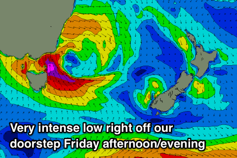
So, we've got a very dynamic and interesting forecast period ahead, with a deep, broad and powerful low expected to develop through tomorrow, sliding east and west of our coast bringing varying large swell pulses and also variable winds.
Tomorrow is due to start tiny but strengthening S/SE winds through the day should kick up an afternoon increase in S/SE windswell to 3-4ft but with poor conditions.
Overnight gale-force S/SE-SE winds will be aimed through our swell window, an embedded lows centre drifting west. This will see winds likely kink SW for a couple of hours Friday morning with a large spike of S/SE groundswell to the 6ft range.
Once the S/SE winds kick back in through the morning, they're expected to go nuclear, strengthening to the severe-gale to near storm-force range right off our coast.
 This will see the surf become very large and stormy across the northern half of the coast late in the day Friday and only protected spots will be handling the swell and wind.
Winds will remain in the severe-gale range out of the SE through Friday evening before slowly weakening Saturday, resulting in large stormy SE swell Saturday morning to 10ft or so with strong to gale-force but improving S/SE tending S/SW winds on the coast.
We'll continue to see the low slowly weakening through Sunday and Monday while aiming a SE fetch towards us and with this the swell will fade slowly in size and power from Saturday afternoon through Sunday and early next week as winds continuing to improve.
We're still looking at surf to an easy 6ft Sunday morning out of the SE with strong S'ly winds, light from the W Monday with easing 3-4ft+ sets.
Once this swell fades there's nothing too major on the cards, but check back here on Friday for the latest.

