Plenty of swell but only clean come the weekend
Eastern Tasmania Surf Forecast by Craig Brokensha (issued Wednesday 21st March)
Best Days: Saturday afternoon, Sunday, Tuesday south magnets
Recap
Flat yesterday with a small weak increase in S/SE windswell through today with average winds.
Today’s Forecaster Notes are brought to you by Rip Curl
This week and weekend (Mar 22 - 25)
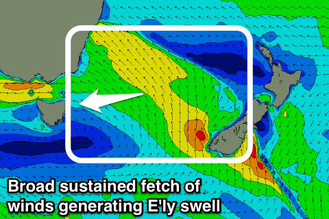
In the wake of yesterday's onshore change we're now seeing a broad fetch of strong SE-E/SE winds extending out across the Tasman Sea, persisting through all of today and tomorrow before weakening into Friday as local NE winds develop down our coast into Saturday.
 What we'll see is poor onshore winds aimed into us tomorrow from the E/NE with building levels of E'ly swell, reaching 3ft+ into the afternoon, a bit smaller early.
A touch more strength and size in the swell is expected on Friday to 3-4ft but with poor fresh NE winds.
We'll see the E/NE swell easing through Saturday likely from 3ft, mixed in with some new NE windswell to a similar 3ft which will persist all day. Winds will swing more N'ly and then N/NW-NW through the afternoon creating improving and fun waves.
Through Saturday evening we'll see a more elongated fetch of N/NE winds develop in our swell window just ahead of a change and this will keep 2-3ft sets hitting north-east magnets Sunday morning before fading through the day under a fresh NW wind.
This change will be linked to a strong mid-latitude moving in from the west and it's due to project a fetch of strong S/SW winds up through our southern swell window Monday evening and Tuesday as it pushes east across us.
A new pulse of S'ly swell in the 3ft+ range is due Tuesday with W'ly tending NE winds, but we'll have a closer look at this Friday.

