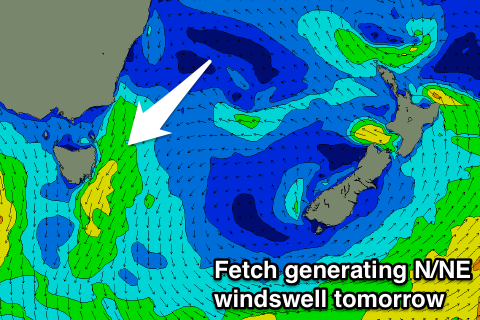
Fun mix of easing S and N/NE swells tomorrow
Eastern Tasmania Surf Forecast by Craig Brokensha (issued Friday 16th March)
Best Days: Saturday, Sunday morning open beaches
Recap
Small leftover amounts of swell from the E/NE yesterday, with some new S'ly energy today but with less than ideal winds that have worsened through the day.
Today’s Forecaster Notes are brought to you by Rip Curl
This week and next week (Mar 17 - 23)
Today's S'ly swell was created by a weakening though broad polar low and front pushing up past the south-east corner of the state.
We'll see the swell ease back through tomorrow from a fun 2-3ft across south magnets, mixed in with a small peaky N/NE windswell.
This windswell will be generated this evening and should come in at 2-3ft across north-east magnets tomorrow morning before easing quickly through the day as a N/NW change moves in.
 Northern corners will be cleanest through the day.
A restrengthening of the N/NE fetch down the coast tomorrow evening will kick the N/NE windswell back up through Sunday morning, keeping 2ft+ sets hitting the coast (fading through the day) with a strong W/NW change.
The swell will then become tiny into early next week under gusty offshore winds as a series of strong fronts push across the state.
This will generate large surf for exposed west and south facing locations, but the activity will be too west to influence us.
A S'ly change Tuesday afternoon and evening is due to kick up some small S'ly swell for Wednesday but with average winds.
Behind this though we may see a high stalling in the Tasman Sea, generating some E'ly swell late week/next weekend, but more on this Monday. Have a great weekend!

