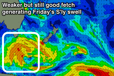
Fading E groundswell with a new onshore S'ly swell Friday
Eastern Tasmania Surf Forecast by Craig Brokensha (issued Wednesday 14th March)
Best Days: Thursday morning, Saturday morning south magnets
Recap
A small fun south swell across magnets yesterday, while today some better E/NE groundswell has filled in, a little slow early though coming in with fun sets this afternoon.
Today’s Forecaster Notes are brought to you by Rip Curl
This week and next week (Mar 15 - 18)
Today's small E/NE groundswell should fade back from an inconsistent 2ft on the sets tomorrow morning with an offshore ahead of sea breezes.
Our S'ly groundswell for Friday has been downgraded a little, with a weaker fetch of strong to gale-force SW winds due to be projected up past our south-east corner tomorrow.
 We may see a late increase in size, but a peak is due Friday morning to 3-4ft across south facing beaches still with those poor winds.
An onshore SE-E/SE wind is expected to swing more E/NE and freshen through the day, creating poor conditions, while Saturday should be cleaner as the S'ly swell eases mixed in with a small NE windswell.
We're looking at fading 2-3ft sets out of the south, mixed in with 2ft+ of NE windswell.
N/NW winds should create clean conditions most of the day.
Into Sunday a persistent fetch of NE winds sitting north-east of us should keep small 1-2ft sets hitting the coast, fading into early next week.
We'll then see the westerly storm track really kick into gear through early-mid next week but large surf due across the South Arm looks to be too west at this stage to impact out region. More on this Friday.

