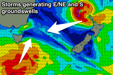
Mix of swells for the period
Eastern Tasmania Surf Forecast by Craig Brokensha (issued Friday 9th March)
Best Days: Sunday morning, Tuesday morning south swell magnets, Wednesday open beaches
Recap
A little slow early yesterday but a good S'ly groundswell filled in through the day with fun waves across south magnets.
The swell is on the ease this morning from a small but clean 2ft on the sets.
Today’s Forecaster Notes are brought to you by Rip Curl
This weekend and next week (Mar 10 - 16)
The last two days of S'ly swell will continue to ease into the weekend, leaving nothing of any size tomorrow.
A small E'ly swell from all the activity in the Tasman Sea aimed towards the northern NSW coast is due to build tomorrow and peak Sunday but only to 1-2ft or so.
There'll also be some fun N/NE windswell to a similar 1-2ft in the mix Sunday from a strengthening fetch of N/NE winds down our coast tomorrow afternoon and evening.
Winds on Sunday should swing from the W/NW to the S/SE mid-afternoon with a change.
The change will be linked to the first of a series of strong cold fronts pushing under us from Sunday through next week.
 This initial front will be too west in nature to generate any S'ly swell for us, but a secondary system Monday will project a slightly better fetch of W/SW gales past the south-east corner of the state.
A small S'ly groundswell is due off this fetch, peaking Tuesday but only to a small 2-3ft across south magnets, more so up the northern end of the coast.
Winds should be favourable with a morning W/NW offshore ahead of sea breezes as the swell eases.
The swell is expected to ease from a small 2ft Wednesday morning, with favourable winds.
Also in the mix Wednesday we're due to now see some small E/NE groundswell from ex Severe Tropical Cyclone Hola which will make an extra-tropical transition above New Zealand.
As it does so a better fetch of severe-gale to storm-force E'ly winds will be aimed towards the East Coast, with an E/NE groundswell arriving later Tuesday and peaking Wednesday in the 3ft range.
Longer term there's possible swells from the NE and S'th, but more on this Monday. Have a great weekend!

