Prolonged NE swell event with a S'ly groundswell in the mix
Eastern Tasmania Surf Forecast by Craig Brokensha (issued Wednesday 14th February)
Best Days: Friday, Saturday, Sunday morning, Tuesday, Wednesday, Thursday
Recap
Tiny surf yesterday while this morning also started tiny but a quick pulse of N/NE swell should have been seen through the late morning just ahead of a strong W'ly change.
Today’s Forecaster Notes are brought to you by Rip Curl
This week and next week (Feb 15 - 23)
Any sign of N/NE swell seen today will be fleeting at best fading back this evening with nothing left tomorrow.
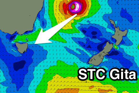
We then look towards the north-east where Severe Tropical Cyclone Gita which is currently category 5, causing havoc across southern Fiji.
We're seeing a small tight fetch of storm to hurricane-force E/NE-NE winds aimed through our north-eastern swell window, with a much weaker fetch of strong E/NE trades on its south-eastern flank.
STC Gita is forecast to retro-grade west then south-west through our north-eastern swell window over the coming days and weekend before drifting south while making an extra-tropical transition in the Tasman Sea Monday, drifting south-southeast Tuesday.
 What this will result in is inconsistent pulses of NE groundswell from Friday through the weekend and early next week swinging more E/NE through the middle of next week then easing rapidly.
Estimating the size is quite tricky with this being a very intense but small storm, though we're likely to see moderate to large surf developing through the weekend, mainly Sunday with a peak in size Monday/Tuesday.
The swell will initially be very inconsistent but increase in consistency through the event.
Open beaches should build very slowly Friday from an inconsistent 2ft during the morning to 3ft on the sets later in the day, with a more noticeable increase Saturday from 3-4ft to 4-5ft later in the day, holding Sunday.
The peak in size looks to be Monday afternoon and Tuesday with 4-6ft sets at swell magnets open to the north-east, with 4-5ft+ waves Wednesday morning more from the east, easing through the day.
There'll be plenty of leftover E'ly swell into the end of the week, but we'll look at this in more detail Friday.
It should be noted that this swell event will be quite lully/pulsey in its early stages, with periods of activity followed by hardly any surf.
Also in the mix Saturday will be a strong S'ly groundswell, generated by an intense polar low forming south-southwest of the state through tomorrow and Friday. We should see south magnets coming in around 4ft through Saturday, easing later in the day and smaller Sunday.
Winds will be great Friday and Saturday but come Sunday a morning W/NW offshore will give into a SE change, lingering Monday. Lighter offshore winds are expected on Tuesday ahead of sea breezes with a possible S'ly change Wednesday, but more on this Friday.

