Good S'ly swell tomorrow, with N/NE and S/SE energy to follow
Eastern Tasmania Surf Forecast by Craig Brokensha (issued Monday 5th February)
Best Days: South magnets tomorrow and early Wednesday, Friday morning, Saturday morning south magnets, Monday morning
Recap
Fun levels of E'ly swell persisting at 2-3ft Saturday after Friday's pulse, while Sunday was back to a tiny 1-1.5ft.
This morning the swell remained tiny but some new S'ly swell should be showing at south magnets this afternoon.
Today’s Forecaster Notes are brought to you by Rip Curl
This week and weekend (Feb 6 - 11)
While this afternoon we should see a new S'ly groundswell pulse on the coast, the best increase is due tomorrow.
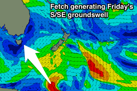
 This has been generated by a broad and elongated polar frontal system projecting from south of us up towards New Zealand.
Good 3ft sets should be seen across south magnets, if not for the odd bigger sneaky one, easing back into the late afternoon, smaller from 2ft Wednesday.
A light offshore wind is expected tomorrow morning ahead of NE sea breezes, with N/NW tending NE winds on Wednesday.
These N/NE winds should generate some new N/NE windswell later in the day Wednesday and more so Thursday but only to 2ft to maybe 3ft across north-east magnets and with less than ideal N tending N/NE winds. We may see a late S'ly change, favouring southern corners, but we'll review this Wednesday.
 Into Friday the N/NE windswell will ease but a new S/SE groundswell is due to peak, generated today and tomorrow morning by a small fetch of gale to severe-gale S/SE winds on the polar shelf south of New Zealand.
We should see fun 3ft sets Friday at south facing spots with a S/SW tending S/SE breeze. N/NW tending N/NE winds will create cleaner conditions Saturday as the S/SE swell eases from 2ft.
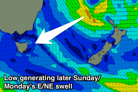
Into Sunday and Monday a tropical low first drifting south towards New Zealand from around Fiji and then retro-grading west towards the Australian East Coast is expected to generate a good fetch of E/SE winds through our eastern swell window.
While not ideally aimed we should still see a fun increase in size to 2-3ft later Sunday and 3ft Monday with morning offshore winds. Check back Wednesday for confirmation on the timing and size of this swell.

