Fun E/SE swell, mixed in with a stronger N/NE windswell
Eastern Tasmania Surf Forecast by Craig Brokensha (issued Wednesday 10th January)
Best Days: Northern corners Friday afternoon and southern corners Saturday morning
Recap
Tiny leftover amounts of N/NE windswell yesterday, replaced by some small E/SE windswell today from a change and developing low to our east.
Today’s Forecaster Notes are brought to you by Rip Curl
This week and weekend (Jan 11 - 14)
Today's small increase in windswell is the start of a small but prolonged E/SE swell event, generated by a developing low in the Tasman Sea to our east.
We're seeing a strengthening fetch of retracting SE winds moving from the central-southern Tasman Sea towards New Zealand. This should produce a better pulse of E/SE swell for tomorrow, building from 2ft during the early morning to 2-3ft through the day.
 The fetch will linger off the tip of New Zealand's South Island through tomorrow before weakening into Friday.
This should keep 2-3ft sets hitting the coast out of the E/SE Friday before easing from a similar size Saturday morning.
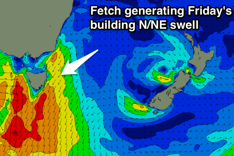
As touched on Monday though, winds will be average as an approaching front from the west squeezes a high between us and the low, resulting in strengthening E/NE tending NE winds tomorrow, stronger from the N/NE Friday.
This will generate building levels of N/NE windswell, likely to 2-3ft by dark tomorrow, while Friday will see larger 3-5ft surf developing.
An offshore change is expected around dark Friday evening, and with this, the swell will ease overnight, further from 3ft or so at north-east magnets early Saturday with a S/SW tending S/SE breeze.
Smaller leftover waves are due into Sunday, with a possible S'ly groundswell kick through the afternoon from a strong but poorly aligned polar low on Friday.
Sets to 2ft are likely but winds are still a little unknown.
Longer term a weak front pushing up past us Monday will likely bring a small increase in windswell, but more on this Friday.

