Small to tiny swells continue
Eastern Tasmania Surf Forecast by Craig Brokensha (issued Monday 18th December)
Best Days: No good days
Recap
Small clean 1-2ft waves Saturday at north-east swell magnets, onshore and tiny Sunday with a weak trough off the coast. This morning was clean again but tiny.
Today’s Forecaster Notes are brought to you by Rip Curl
This week and weekend (Dec 19 - 24)
As touched on last update, there still isn't much to get excited about over the coming forecast period.
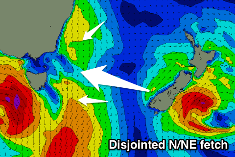
A strong low that's currently forming and approaching from the west will squeeze a high in the Tasman Sea, with a disjointed fetch of N/NE winds due to be aimed through our northern swell window.
 This disjointed nature isn't ideal at all, as it will reduce the swell generating capabilities of the N/NE windswell.
We're now only due to see 1-2ft waves with poor N/NE winds tomorrow afternoon, clean Wednesday morning but fading from a tiny 1-1.5ft.
As the low passes under us Wednesday afternoon, it will produce a zonal fetch of W/SW gales and hence no significant S'ly groundswell is expected.
If we do see any size it will be on dark Thursday and only to 1-2ft at south magnets.
A secondary more polar but less than favourably aligned front will generate another S'ly groundswell for late Friday and Saturday morning but again you'll be lucky to see 1-2ft sets at south magnets.
Early next week we may see some new S'ly windswell out across the coast, but more on this Wednesday.

