Tiny swells for the period
Eastern Tasmania Surf Forecast by Craig Brokensha (issued Friday 15th December)
Best Days: No good days
Recap
A fun clean NE windswell yesterday with developing offshore winds and a peak through the day. This morning only a small leftover 1-2ft of swell has been seen with light offshore winds.
Today’s Forecaster Notes are brought to you by Rip Curl
This week and weekend (Dec 16 - 22)
Unfortunately there isn't much to talk about this coming period.
There's a few tiny swells due over the weekend, namely a leftover long-range and inconsistent E/NE swell tomorrow, not above 1ft though with offshore winds.
 A weak trough on Sunday will bring onshore SE winds and a small weak increase in windswell through the afternoon to 1-1.5ft, if that.
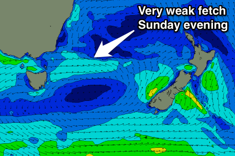
A small burst of weak E/NE winds towards us Sunday evening may produce another tiny 1-1.5ft windswell Monday afternoon, though with NE winds.
Unfortunately a weak fetch of N/NE winds developing down our coast Tuesday and Wednesday morning won't really reach any strength and be short-lived in our swell window.
A tiny 1-1.5ft of NE windswell may be seen later Tuesday and Wednesday morning with offshore NW winds, fading into the afternoon with a strong W'ly change.
The change will be linked with a strengthening polar low south-west of the state mid-week, but the fetches within this low look a little too west in position and alignment to generate any meaningful S'ly swell for our region.
We'll have a closer look at this Monday though. Have a great weekend!

