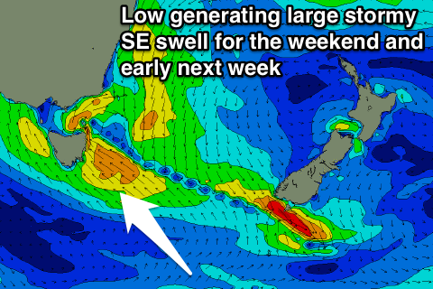
Building N/NE swell followed by larger stormy SE swell
Eastern Tasmania Surf Forecast by Craig Brokensha (issued Wednesday 29th November)
Best Days: Later Friday, southern corners over the weekend and early next week
Recap
A small mix of leftover NE and SE swells yesterday to 1-2ft max, while today the NE swell is continuing at an infrequent 1-2ft for keen surfers.
Today’s Forecaster Notes are brought to you by Rip Curl
This week and weekend (Nov 30 – Dec 3)
Tomorrow will be the smallest of the period, with a small to tiny mix of leftover NE and small SE swells, not getting above 1-2ft with N/NW tending fresher N/NE winds.
Later in the day we'll see winds start to strengthen off the coast, kicking up some small but weak NE windswell on dark to 2ft+ or so.
Through Thursday evening and Friday we'll see a better fetch of N/NE winds developing in our swell window, though the structure of this setup has changed since Monday, with the deepening surface trough moving in from the west expected to move into the Tasman Sea and turn into a low during Saturday.
This will cut off the infeed of NE winds down to our region, resulting in less size.
We'll however see a strengthening fetch of SE winds being aimed into us over the weekend, generating larger amounts of SE swell, peaking later Sunday and easing Monday as the low weakens.
 The N/NE windswell should reach 3ft+ across north-east facing beaches through Friday and winds will swing from the N'th during the morning, W/NW then S'ly later in the day. This will favour southern corners picking up the north swell.
The swell is then expected to be smaller from the NE for most of the period, to 2ft to sometimes 3ft, but the SE swell will become much larger.
Stormy building surf from the S/SE is due Saturday, reaching 4-5ft across south facing beaches later in the day, while stronger gale-force winds will whip up larger surf to the 8ft range Sunday afternoon or so though with terrible conditions. All but protected southern corners will be a large dangerous mess.
As the low weakens into Monday though, winds are due to swing more S/SW during the morning resulting in cleaner surf and easing sets from the 6ft+ range, smaller into Tuesday and Wednesday.
With the dynamic nature of this setup we'll have to take a complete fresh look on the outlook Friday.


Comments
Hello, why do I not see this SE swell forming below Tasmania on METEYE? It all points to a NE swell as far as I can see. Help me out here boys, I'm confused!
Hmm not sure, unless it hasn't updated with the most recent forecasts.. You can see the fetch on our WAMs and the BOM wind charts as well.
Windy tv -click on pressure isolines.