Fun N/NE swell strengthening through tomorrow, fading Friday
Eastern Tasmania Surf Forecast by Craig Brokensha (issued Wednesday 18th October)
Best Days: Thursday midday onwards, Friday morning
Recap
A sneaky south pulse yesterday morning, offering 1-2ft sets, fading back today with a new tiny N/NE windswell that should currently be increasing in size.
This week and weekend (Oct 19 - 22)
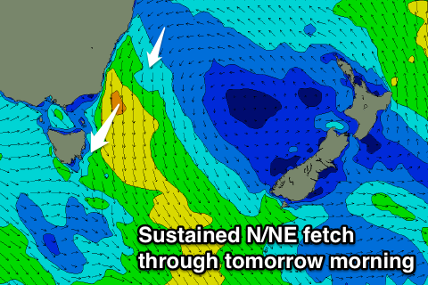
We're currently seeing a mid-latitude front pushing in from Western Australia, squeezing a strong slow moving high in the Tasman Sea, resulting in a strengthening and broadening fetch of N/NE winds down through our swell window.
 This fetch will reach maturity through the early hours of tomorrow morning but actually stall a little longer through our swell window before pushing east and dissipating tomorrow afternoon.
With this we're looking at a whole day of decent N/NE swell, with even some small waves holding into early Friday.
North-east facing beaches should build to 3-4ft through the late morning and remain that size through until the evening, easing back from 2ft or so Friday morning.
Less than ideal N/NW winds are due tomorrow morning, tending more NW late morning and then straight W'ly into the late afternoon/early evening. Therefore an afternoon/evening surf is the go.
Friday will then see W/SW winds most of the day, tending S/SW later.
Moving into the weekend the outlook remains void of any major swells with a weak S'ly change Sunday kicking up a poor small windswell, fading as quickly as it comes. Following this there's nothing significant for next weekend, but more on this Friday.

