Large S'ly swell tomorrow, easing from Sunday

Eastern Tasmania Surf Forecast by Craig Brokensha (issued Friday 8th September)
Best Days: Saturday, Sunday, Monday morning south magnets
Recap
Some fun S'ly swell easing yesterday morning from 2-3ft at south swell magnets, while today, some new S'ly energy was pushing in across the region though with less favourable winds.
This weekend and next week (Sep 9 - 15)
Today's S'ly swell was generated by a strong polar front pushing up and past us last night and early this morning, but we've got a much better, stronger and more favourably aligned S'ly groundswell swell event due for the weekend.
The polar front responsible for today's swell is stalling to our south-southeast, with a tight low pressure system forming this morning.
 We're seeing a broad and elongated fetch of strong to gale-force S/SW winds in our southern swell window, with the embedded low generating a tighter fetch of severe-gale to storm-force winds, just within our swell window.
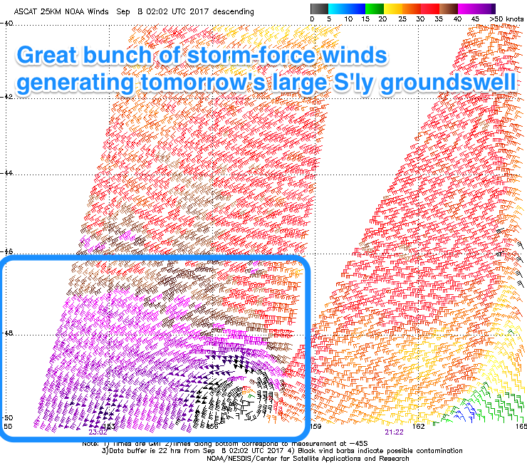
Satellite observations have just come in and have verified a great bunch of storm-force winds right on the edge of our swell window.
What we should see is a large S'ly groundswell filling in tomorrow, peaking from late morning/early afternoon and offering strong 6ft sets across south facing beaches, easing off slowly from the 4ft range Sunday, smaller and from 2ft to occasionally 3ft Monday.
Winds tomorrow aren't ideal but good for open beaches with a moderate and persistent W/SW breeze, while Sunday looks good with W'ly tending variable winds. As the swell fades Monday, better NW winds will kick in, favouring south magnets.
Our next increase in swell looks to be Thursday as a strong mid-latitude front pushes across us, possibly strengthening as it does so. This will generate some close-range S'ly swell, but more on this Monday. Have a great weekend!