S'ly swell to come, largest Friday
Eastern Tasmania Surf Forecast by Craig Brokensha (issued Monday 4th September)
Best Days: Thursday morning south magnets, open beaches Friday, south magnets Saturday and Sunday morning
Recap
Good clean fun waves out of the east Saturday, back to a small 1-2ft Sunday with early light winds. A small N/NE windswell that developed through yesterday has faded overnight leaving tiny waves this morning.
This week and weekend (Sep 5 - 10)
This week we look to our south for swell, with a couple of significant cold-outbreaks due to move up past our south-east corner.
The first on Wednesday won't be too favourably aligned, with a fetch of strong W/SW winds pushing past us expected to generate a small refracted Sly groundswell for later in the day and Thursday morning.
I'm not overly confident on this swell getting in with a possible late increase Wednesday afternoon to 2-3ft across south magnets, easing from a similar size Thursday morning. Winds will hold from the W/SW most of Wednesday, tending W/NW Thursday morning favouring south magnets.
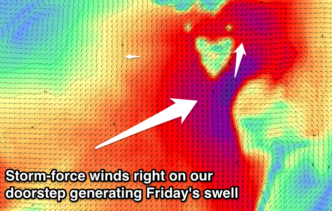
 A much stronger and better aligned cold-outbreak is due on Thursday evening, with a very significant fetch of storm-force S/SW winds due to be generated through our southern swell window into early Friday.
This system will race off to the west during the day Friday, but we'll continue to see SW gales aimed through our swell window.
A large consistent S'ly swell will be generated, peaking during the morning in the 6ft+ range across south facing beaches, much smaller at other open beaches.
The swell isn't expected to ease too much through the afternoon, with Saturday morning still seeing 4ft sets, fading through the day.
Winds on Friday will be average for south facing locations with a fresh to strong SW winds, better from the W/SW tending W Saturday.
Sunday isn't due to see much leftover size at all with fading 2ft sets but with W/NW winds.
Longer term there's nothing too major on the cards so try and work around Friday's and the weekend's swell.

