Small swells, best later in the week
Eastern Tasmania Surf Forecast by Craig Brokensha (issued Monday 28th August)
Best Days: Tuesday, Thursday morning at south magnets, Friday afternoon and Saturday south magnets
Recap
No surf Saturday but some new S'ly swell filled in Sunday though with average winds for spots picking up the size. Today conditions were cleaner with the swell hanging in at 2-3ft out of the south.
This week and weekend (Aug 29 – Sep 3)
Our current S'ly swell is expected to drop right back through tomorrow with no major size left at all across south magnets.
A small E'ly signal from a fetch of E/NE winds feeding into a Tasman Low that formed off the southern NSW coast should provide 1-2ft sets at open beaches though, fading into Wednesday.
Conditions will be great all day tomorrow with a persistent W/NW breeze.
 Our next pulse of swell looks to arrive Wednesday and out of the south, with a strong polar front projects up and past us around dawn.
A fetch of strong S/SW winds should kick up some decent sized S'ly swell through the day, reaching 3ft+ across south facing beaches but with poor SW tending S'ly winds.
Thursday will see the swell ease off quickly from 2ft+ across south magnets along with a light W/NW tending E'ly breeze.
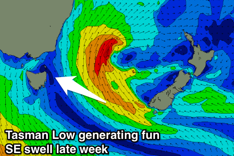
Wednesdays change will trigger the formation of a Tasman Low between us and New Zealand, and with this we'll see a good fetch of SE winds aimed through our swell window on Thursday and Friday before breaking down Friday evening.
Some good SE swell is due off this low, building through Friday to 2-3ft at open beaches, easing from a similar size Saturday morning.
Winds are a slight issue Friday with strengthening N'ly breezes, leaving northern corners with the best conditions, while Saturday with see W/NW offshores.
Longer term there's nothing significant through next week until later when we'll see a strong node of the Long Wave Trough pushing slowly east across the region, likely bringing some large S'ly swell. More on this Wednesday.

