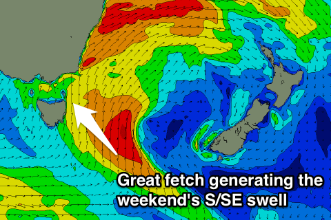
Great S/SE swell over the weekend
Eastern Tasmania Surf Forecast by Craig Brokensha (issued Friday 18th August)
Best Days: Saturday semi-protected spots, Sunday, Monday morning
Recap
Another day of tiny surf yesterday, but today some new S'ly swell is on the build and we should see some decent size by dark today but with average winds.
This weekend and week (Aug 19 - 25)
Currently a polar front is pushing up past us while deepening, and we're now due to see a stronger fetch of S/SE gales generated in our swell window this evening.
 This should help produce a larger pulse of S/SE swell through tomorrow, with south facing beaches expected to see 4-5ft sets, with 2-3ft waves at more open spots.
The swell looks to hold most of the day, with Sunday providing good easing 3ft sets across south magnets, smaller through the day.
We'll likely see small levels of SE swell persisting at 1-2ft through Monday morning due to a good fetch of SE gales being generated off the south-east tip of New Zealand's South Island, flat Tuesday.
Winds tomorrow will remain a little suss with a SW breeze, tending more W through the afternoon and then great W/NW winds all day Sunday, more N/NW Monday.
Beyond this there's nothing major on the cards at all for the rest of the week, so make the most of the weekend's swell.

